 Filter: Categories of Wisconsin Historical Images
Filter: Subject of Ocean
Filter: Categories of Wisconsin Historical Images
Filter: Subject of Ocean

| Date: | 1857 |
|---|---|
| Description: | Information depicting the history, condition and prospects of the Indian tribes of the United States: collected and prepared under the direction of the Bur... |

| Date: | 1780 |
|---|---|
| Description: | Contenant: New Hampshire, Massachusetsbaye, Rhode Island, Connecticut, La Nouvelle York, Nouvelle Jersey, La Pensilvanie, Les Comtes de Newcastle, Kent et ... |

| Date: | 1798 |
|---|---|
| Description: | Uncolored. No scale. One of the earliest maps to show the proposed division of the northwest territory into states. |

| Date: | 10 22 1943 |
|---|---|
| Description: | View across water of Mushu Island in the distance. There is a ship in the foreground, an airplane above, and the appearance of explosions in the water. |

| Date: | 1813 |
|---|---|
| Description: | Eastern half of the United States. Scale: 2.5 inches = 250 miles. |

| Date: | 1850 |
|---|---|
| Description: | [... through northern United States from New York to Minnesota]. Lithography by T. Sinclair. From Perrault papers, Lucien S. Hanks, donor. |

| Date: | 1755 |
|---|---|
| Description: | From "A map of the British and French dominions in North American with the roads, distances, limits, and extent of the settlements". |

| Date: | 1772 |
|---|---|
| Description: | Scale: about 180 miles to 1 in. |

| Date: | 1755 |
|---|---|
| Description: | Color map of North American territories owned by the English and by the French. Scale: about 115 milles d'Angleterre to 1 inch. French title is "Carte des ... |

| Date: | 1824 |
|---|---|
| Description: | Drawn and engraved by Sidney Hall. Published by Longman, Hurst, Rees, Orme, Brown & Green. Scale: 1:200. Partly colored. This is probably the second Europe... |
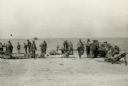
| Date: | 11 13 1942 |
|---|---|
| Description: | Headquarters of the 32nd American Division, on the beach at Pongani, northeast New Guinea. |

| Date: | 1939 |
|---|---|
| Description: | Aerial view of International Harvester's Geelong Works in Geelong, Victoria, Australia. |
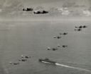
| Date: | 04 20 1944 |
|---|---|
| Description: | Aerial view of three TBF's (all above the horizon) and eleven SBD's, which participated in Pacific Fleet's carrier-strike against Japan's bases in the Pala... |

| Date: | |
|---|---|
| Description: | Panoramic collotype of Havana, Cuba harbor. Numerous boats are visible. Sky appears to have been masked out before printing. |
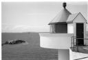
| Date: | 1996 |
|---|---|
| Description: | Fjoloy Lighthouse on the coast of in Stavanger, Norway. |

| Date: | 12 1951 |
|---|---|
| Description: | Philleo Nash (playing the guitar), Presidential adviser on Minority Affairs, entertains President Harry Truman (in the sunglasses), with folk songs during ... |

| Date: | 11 25 1951 |
|---|---|
| Description: | President and Mrs. Truman and Margaret Truman motoring from the Little White House to Truman Beach in Key West. |
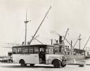
| Date: | 06 03 1925 |
|---|---|
| Description: | International "outer harbor" bus parked near a large boat and several harbor buildings. The bus was built on an International model 52 or model 53 chassis. |

| Date: | 1835 |
|---|---|
| Description: | Map reads: "Map of the United States of America with its Territories and Districts - Including also a part of Upper and Lower Canada and Mexico". The map i... |
If you didn't find the material you searched for, our Library Reference Staff can help.
Call our reference desk at 608-264-6535 or email us at:
