 Filter: Categories of Wisconsin Historical Images
Filter: Subject of Ocean
Filter: Year of 1800-1899
Filter: Year of 1870-1879
Filter: Categories of Wisconsin Historical Images
Filter: Subject of Ocean
Filter: Year of 1800-1899
Filter: Year of 1870-1879

| Date: | 1877 |
|---|---|
| Description: | Map showing location of Indian reservations in the United States and population figures. |

| Date: | 1878 |
|---|---|
| Description: | This lithograph shows Greenland, North America, Central America, South America, Polynesia, Australia, the Pacific Ocean, the Atlantic Ocean, the Arctic Oce... |

| Date: | 1878 |
|---|---|
| Description: | This lithograph shows Africa, Europe, Asia, Australia, and the Antarctic Continent, the Atlantic Ocean, the Indian Ocean, the Arctic Ocean, the Pacific Oce... |
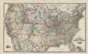
| Date: | 1878 |
|---|---|
| Description: | This map shows railroad lines, states, cities, rivers, and a small portion of Canada and Mexico. States appear in pink, yellow, and green. The Gulf of Mexi... |

| Date: | 1871 |
|---|---|
| Description: | A map of California showing railroad lines and reservations. |
If you didn't find the material you searched for, our Library Reference Staff can help.
Call our reference desk at 608-264-6535 or email us at:

