 Filter: Categories of Wisconsin Historical Images
Filter: Subject of Ocean
Filter: Year of 1800-1899
Filter: Year of 1860-1869
Filter: Categories of Wisconsin Historical Images
Filter: Subject of Ocean
Filter: Year of 1800-1899
Filter: Year of 1860-1869
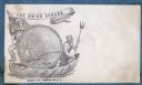
| Date: | 1860 |
|---|---|
| Description: | A Union sailor and King Neptune stand inside a sea shell that is floating on the ocean. Between them appears a decorative circle with the Union Armada in i... |
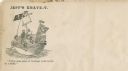
| Date: | 1860 |
|---|---|
| Description: | Jefferson Davis and six sailors sail in a tea cup. A pirate flag flies overhead. One sailor is in the "crow's nest." Another is using a paddle. Three sailo... |

| Date: | 1866 |
|---|---|
| Description: | Exterior of Fort Sumter. A cannon has fallen on the steep shoreline and waves are hitting the rocks. Plate 58 |

| Date: | 1861 |
|---|---|
| Description: | A general map of Pennsylvania, Virginia, New Jersey and Delaware. Insets include maps of New Orleans, Baltimore, St. Louis, Charleston, Savannah, Washingto... |

| Date: | 1865 |
|---|---|
| Description: | This map of Maryland and Virginia shows railroads, rivers, cities and towns, and the positions of Confederate troops and defenses in Virginia in 1861. |

| Date: | 1860 |
|---|---|
| Description: | This colored map shows railroad lines east of the Mississippi as well as in the states bordering the Mississippi River. The Great Lakes and Gulf of Mexico ... |

| Date: | 1862 |
|---|---|
| Description: | This map of the southeastern United States shows cities and towns, rail lines, and geographic features such as rivers, mountains, lakes, and swamps. |

| Date: | 1862 |
|---|---|
| Description: | This map of the southeastern United States shows forts and battlefields, railroads, rivers, and cities and towns. Dates of admission and secession of the s... |

| Date: | 1863 |
|---|---|
| Description: | A general map of the southeastern United States showing Missouri, Kentucky, West Virginia, Virginia, North Carolina, South Carolina, Georgia, Florida, Alab... |

| Date: | 1868 |
|---|---|
| Description: | Map showing the northern water routes between Mississippi River and Atlantic Ocean Relief shown by hachures. Includes Profile of the Erie Canal, table of ... |

| Date: | 1868 |
|---|---|
| Description: | This map is one of the earliest weather maps of the United States, which traced an 1859 storm across the continent. Manuscript annotations in red ink show ... |
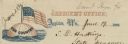
| Date: | 06 19 1862 |
|---|---|
| Description: | Letterhead of a globe floating in the ocean. The text: "Our Country" is printed onto the globe. The American flag is flying from the top of the globe. Text... |

| Date: | 1864 |
|---|---|
| Description: | A map of Sherman's March from Atlanta, Georgia to Goldsboro, North Carolina. |

| Date: | 1867 |
|---|---|
| Description: | A map and profile map of the railroad line from Omaha to San Francisco. |
If you didn't find the material you searched for, our Library Reference Staff can help.
Call our reference desk at 608-264-6535 or email us at: