 Filter: Categories of Wisconsin Historical Images
Filter: Subject of Ocean
Filter: Year of 1800-1899
Filter: Categories of Wisconsin Historical Images
Filter: Subject of Ocean
Filter: Year of 1800-1899
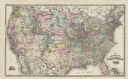
| Date: | 1878 |
|---|---|
| Description: | This map shows railroad lines, states, cities, rivers, and a small portion of Canada and Mexico. States appear in pink, yellow, and green. The Gulf of Mexi... |

| Date: | 1871 |
|---|---|
| Description: | A map of California showing railroad lines and reservations. |
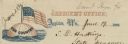
| Date: | 06 19 1862 |
|---|---|
| Description: | Letterhead of a globe floating in the ocean. The text: "Our Country" is printed onto the globe. The American flag is flying from the top of the globe. Text... |

| Date: | 1853 |
|---|---|
| Description: | A map of Wellfleet Harbor on Cape Cod Bay. |

| Date: | 1897 |
|---|---|
| Description: | Circular-framed view across a body of water. Two wood pilings are in the right foreground, and a boat is out on the water. Hills are along the far shorelin... |

| Date: | 1864 |
|---|---|
| Description: | A map of Sherman's March from Atlanta, Georgia to Goldsboro, North Carolina. |

| Date: | 1867 |
|---|---|
| Description: | A map and profile map of the railroad line from Omaha to San Francisco. |
If you didn't find the material you searched for, our Library Reference Staff can help.
Call our reference desk at 608-264-6535 or email us at: