 Filter: Categories of Wisconsin Historical Images
Filter: Subject of Ocean
Filter: Subject of transportation
Filter: Categories of Wisconsin Historical Images
Filter: Subject of Ocean
Filter: Subject of transportation

| Date: | 06 1942 |
|---|---|
| Description: | A crew member of the United Fruit Company's S.S. Santa Marta looking over the side of the freighter at the Caribbean Sea and the clouds. The man is ... |
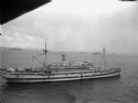
| Date: | 04 1945 |
|---|---|
| Description: | Elevated view of a newly commissioned hospital ship, the USS Bountiful, in the Ulithi Harbor. The ship was previously called the USS Henderson |
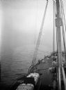
| Date: | 04 1945 |
|---|---|
| Description: | The sunrise aboard the USS Relief in the China Sea. The mast and bow of the ship are pointed eastward, into the fog and towards the rising sun. |
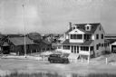
| Date: | |
|---|---|
| Description: | View of oceanside residences along a town's main street. |
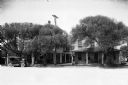
| Date: | |
|---|---|
| Description: | View downhill towards a neighborhood crowded with cottages. |

| Date: | 07 1941 |
|---|---|
| Description: | Advertising proof for International trucks, featuring color illustrations of a truck and the United States, largely in red, white and blue. Includes the te... |

| Date: | |
|---|---|
| Description: | View of a cottage separated from Oyster Pond by fences and an unpaved road. |

| Date: | |
|---|---|
| Description: | View of expansive gardens rolling down to a harbor. |
| Date: | |
|---|---|
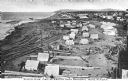
| Description: | Elevated view of an Eskimo tent village on sandspit along the shoreline. Wood buildings are along higher ground on the right near a river. |

| Date: | 1861 |
|---|---|
| Description: | A general map of Pennsylvania, Virginia, New Jersey and Delaware. Insets include maps of New Orleans, Baltimore, St. Louis, Charleston, Savannah, Washingto... |

| Date: | 1865 |
|---|---|
| Description: | This map of Maryland and Virginia shows railroads, rivers, cities and towns, and the positions of Confederate troops and defenses in Virginia in 1861. |
| Date: | |
|---|---|
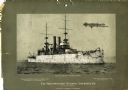
| Description: | Battleship U.S.S. Wisconsin at sea with several men on deck. The mounted photograph was a promotional item for Northwestern National Insurance, Co. |

| Date: | 1860 |
|---|---|
| Description: | This colored map shows railroad lines east of the Mississippi as well as in the states bordering the Mississippi River. The Great Lakes and Gulf of Mexico ... |

| Date: | 1778 |
|---|---|
| Description: | This Italian map from 1778 depicts the upper portion of the Old Northwest. Rivers and lakes are identified and relief, real and imagined, is depicted picto... |

| Date: | 1862 |
|---|---|
| Description: | This map of the southeastern United States shows cities and towns, rail lines, and geographic features such as rivers, mountains, lakes, and swamps. |

| Date: | 1862 |
|---|---|
| Description: | This map of the southeastern United States shows forts and battlefields, railroads, rivers, and cities and towns. Dates of admission and secession of the s... |

| Date: | 1899 |
|---|---|
| Description: | A map showing the shoreline of a portion of El Montecito, Santa Barbara County, California. The map shows properties along the Pacific Ocean, and may have ... |
| Date: | 1920 |
|---|---|
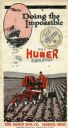
| Description: | Front cover of a pamphlet advertising the Huber Light Four tractor, featuring text reading: "Doing the Impossible." Includes an illustration of a farmer dr... |

| Date: | 1952 |
|---|---|
| Description: | Map of the barley-growing regions of North America, published by the Rahr Malting Company, Manitowoc, Wisconsin, 1952. |

| Date: | 1868 |
|---|---|
| Description: | Map showing the northern water routes between Mississippi River and Atlantic Ocean Relief shown by hachures. Includes Profile of the Erie Canal, table of ... |
If you didn't find the material you searched for, our Library Reference Staff can help.
Call our reference desk at 608-264-6535 or email us at: