 Filter: Categories of Wisconsin Historical Images
Filter: Subject of Ocean
Filter: Subject of signs and symbols
Filter: Categories of Wisconsin Historical Images
Filter: Subject of Ocean
Filter: Subject of signs and symbols
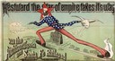
| Date: | 1886 |
|---|---|
| Description: | Advertisement for the Atchison, Topeka and Santa Fe Railroad featuring an illustration of Uncle Sam stretched from the Missouri River to the Pacific Ocean.... |
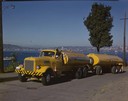
| Date: | 1951 |
|---|---|
| Description: | Color photograph of an International LD-400 series tanker truck owned by Eastern Washington Transports, Inc., on a road near the Port of Seattle. |
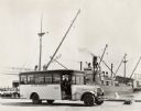
| Date: | 06 03 1925 |
|---|---|
| Description: | International "outer harbor" bus parked near a large boat and several harbor buildings. The bus was built on an International model 52 or model 53 chassis. |
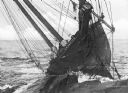
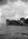
| Date: | 1930 |
|---|---|
| Description: | The bow of a large shipwrecked boat, the E.M. Sawyer, tipped up on a rocky shore. |
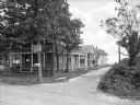
| Date: | |
|---|---|
| Description: | View from unpaved road toward houses down a side dirt road leading toward a beach in the background. A man stands on the porch of the house in the left for... |
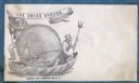
| Date: | 1860 |
|---|---|
| Description: | A Union sailor and King Neptune stand inside a sea shell that is floating on the ocean. Between them appears a decorative circle with the Union Armada in i... |
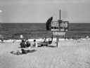
| Date: | 1915 |
|---|---|
| Description: | An elevated lifeguard station stands on the sand at Wriests Beach while people sunbathe on the beach and wade in the water. The sign on the lifeguard stati... |

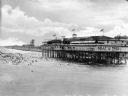
| Date: | 1915 |
|---|---|
| Description: | View along boardwalk, with people sitting, and other people walking. Buildings are along the left, and on the right is a lifeguard tower that looks down o... |
| Date: | |
|---|---|
| Description: | People swim in front of a large observation deck on Katy Lake. Flags fly from the deck's roof and a sign reading "Kelly Tires" hangs from its exterior. A b... |
| Date: | |
|---|---|
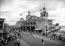
| Description: | Crowds walk along the boardwalk at Funchase amusement pier. A building with flags flying from its turrets features a sign that reads "Funchase Skating". T... |
| Date: | 1920 |
|---|---|
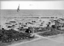
| Description: | Elevated view of the Dipsy Baths outbuilding and surrounding beach. Umbrellas are set up in the sand where people sunbathe or wade in the water, and an Ame... |

| Date: | 1959 |
|---|---|
| Description: | Aerial view of the island of Cuba taken from a small plane. Part of the plane with a Cuban flag painted on it is in the frame, and the island with many bui... |
| Date: | 1942 |
|---|---|
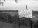
| Description: | A soldier walks along the edge of a cliff in Panama, behind stacks of cannonballs and a large sign. The man is wearing a uniform and is holding a sub-machi... |
| Date: | 04 1945 |
|---|---|
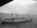
| Description: | Elevated view of a newly commissioned hospital ship, the USS Bountiful, in the Ulithi Harbor. The ship was previously called the USS Henderson |
| Date: | 04 04 1945 |
|---|---|
| Description: | Tank Landing Ship 929 during an operation in Buckner Bay, Okinawa. Other ships are in the background. |
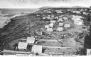
| Date: | |
|---|---|
| Description: | Elevated view of an Eskimo tent village on sandspit along the shoreline. Wood buildings are along higher ground on the right near a river. |

| Date: | 1861 |
|---|---|
| Description: | A general map of Pennsylvania, Virginia, New Jersey and Delaware. Insets include maps of New Orleans, Baltimore, St. Louis, Charleston, Savannah, Washingto... |

| Date: | 02 05 1944 |
|---|---|
| Description: | General view of Port Moresby Harbor from road, New Guinea (present day Papua New Guinea). A jeep is on the road on the left. Several soldiers are near a sh... |
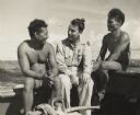
| Date: | 06 1945 |
|---|---|
| Description: | Micronesian men, who put thatched roofs on buildings in the western Caroline Islands for United States forces, sit chatting with Robert J. Doyle, The Journ... |

| Date: | 1720 |
|---|---|
| Description: | Double hemispherical world map showing routes of Tasman, Magellan, Mendana, etc. Relief shown pictorially. Title in oak wreath cartouche. Map between four ... |
If you didn't find the material you searched for, our Library Reference Staff can help.
Call our reference desk at 608-264-6535 or email us at: