 Filter: Categories of Wisconsin Historical Images
Filter: Subject of Ocean
Filter: Subject of sailing ships
Filter: Subject of arts
Filter: Categories of Wisconsin Historical Images
Filter: Subject of Ocean
Filter: Subject of sailing ships
Filter: Subject of arts

| Date: | 1655 |
|---|---|
| Description: | Map from Drake Expedition, ca. 1585. |
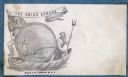
| Date: | 1860 |
|---|---|
| Description: | A Union sailor and King Neptune stand inside a sea shell that is floating on the ocean. Between them appears a decorative circle with the Union Armada in i... |
| Date: | 02 02 1951 |
|---|---|
| Description: | Front cover of the menu and program for the Fifth Anniversary of the Secretary-Generalship of Trygve Lie, first Secretary-General of the United Nations (UN... |

| Date: | 1712 |
|---|---|
| Description: | Engraved double-hemispherical world map by Moll, included in his atlas The world described, or, A new and correct sett of maps: shewing the kingdoms and st... |

| Date: | 1785 |
|---|---|
| Description: | Map of part of North America engraved and hand-colored (the light brown design is a superposition of the map and cartouche derived from the oxidation of th... |
| Date: | |
|---|---|
| Description: | Black and white photograph of a watercolor depicting the sailing ship Tuisco, an immigrant boat. See Image #28146. |

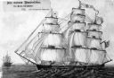
| Date: | |
|---|---|
| Description: | An illustration of a three-masted sailing ship in the ocean. |

| Date: | 1612 |
|---|---|
| Description: | Map of New France, the area that is now eastern Canada and north eastern United States, showing lakes, rivers, and landforms. The locations of several Nati... |
If you didn't find the material you searched for, our Library Reference Staff can help.
Call our reference desk at 608-264-6535 or email us at: