 Filter: Categories of Wisconsin Historical Images
Filter: Subject of Ocean
Filter: Subject of prints
Filter: Categories of Wisconsin Historical Images
Filter: Subject of Ocean
Filter: Subject of prints

| Date: | 1655 |
|---|---|
| Description: | Map from Drake Expedition, ca. 1585. |
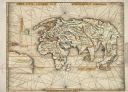
| Date: | 1513 |
|---|---|
| Description: | This exquisite woodcut map is one of the first to show any part of North America. It originally appeared in the 1513 Strasbourg edition of Ptolemy's Geogra... |

| Date: | |
|---|---|
| Description: | Bird's-eye view lithograph of Key West with ships and smaller boats in the surrounding waters. |

| Date: | 1968 |
|---|---|
| Description: | Editorial cartoon of dolphins in the water watching a mushroom cloud explode on the horizon. The drawing is titled, "Blessed Are The Meek: For They Shall I... |

| Date: | |
|---|---|
| Description: | An illustration of a three-masted sailing ship in the ocean. |
If you didn't find the material you searched for, our Library Reference Staff can help.
Call our reference desk at 608-264-6535 or email us at:
