 Filter: Categories of Wisconsin Historical Images
Filter: Subject of Ocean
Filter: Subject of islands
Filter: Categories of Wisconsin Historical Images
Filter: Subject of Ocean
Filter: Subject of islands

| Date: | 1744 |
|---|---|
| Description: | Paris: 1744. W 92⁰--W 76⁰/N 49⁰--N 41⁰. Scale [ca. 1:4,000,000] |
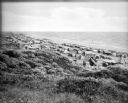
| Date: | |
|---|---|
| Description: | Tents line a beach along the Atlantic Ocean. Foliage covers the foreground and several people and vehicles can be seen throughout the camp. |
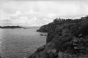
| Date: | |
|---|---|
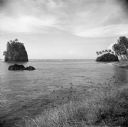
| Description: | View of Kettle Island as seen from Coolidge Point. A residence stands among trees on Coolidge Point. |

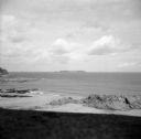
| Date: | |
|---|---|
| Description: | Elevated view of Bermuda shoreline. Several dwellings stand on top of the island and people swim in the ocean on the beaches below. |

| Date: | |
|---|---|
| Description: | Bird's-eye view lithograph of Key West with ships and smaller boats in the surrounding waters. |

| Date: | 1959 |
|---|---|
| Description: | Aerial view of the island of Cuba taken from a small plane. Part of the plane with a Cuban flag painted on it is in the frame, and the island with many bui... |
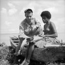
| Date: | 08 24 1943 |
|---|---|
| Description: | An indigenous woman wearing a grass shirt sits on a carved boat with Robert Doyle on the shore of Kiriwina Island in the Solomon Sea, New Guinea (present d... |
| Date: | 08 31 1944 |
|---|---|
| Description: | View from shoreline of Cezembre Island, just north of Saint-Malo on the north coast of France. It was German-occupied until the Allies mounted an operation... |

| Date: | 1918 |
|---|---|
| Description: | Map showing Aleppo, Zor, Syria, Lebanon, Beirut, Jerusalem, with an inset map of the Sinai Peninsula and Egyptian frontier. Also shows the locations of rai... |

| Date: | 02 20 1945 |
|---|---|
| Description: | The caption in the Milwaukee Journal, says it best, "From the far-off Pacific (somewhere on Kwajalein), the picture of Ensign Ray Hanson and Robert ... |
| Date: | 02 28 1945 |
|---|---|
| Description: | Robert Doyle notes, "Strange island near Pago Pago." He was on Tutuila Island, in American Samoa, in the South Pacific. Palm trees are growing on the shore... |

| Date: | 07 21 1925 |
|---|---|
| Description: | Dinner menu from the Hotel St. Catherine, with a color postcard at the top, meant to be detached and mailed, with a view of the hotel against a backdrop of... |

| Date: | 1720 |
|---|---|
| Description: | Double hemispherical world map showing routes of Tasman, Magellan, Mendana, etc. Relief shown pictorially. Title in oak wreath cartouche. Map between four ... |

| Date: | 1740 |
|---|---|
| Description: | From Weigel's Atlas portatilis, oder, Compendieuse Vorstellung der gantzen Welt. Map of Europe. |

| Date: | 1712 |
|---|---|
| Description: | Engraved double-hemispherical world map by Moll, included in his atlas The world described, or, A new and correct sett of maps: shewing the kingdoms and st... |

| Date: | 1696 |
|---|---|
| Description: | Engraved and hand-colored map of Ethiopia, from Blaeu's General Atlas. Map title is framed by a man and a woman, both wearing head turbans, who are standin... |

| Date: | 1798 |
|---|---|
| Description: | Engraved and hand-colored map of Egypt. Map title appears on bottom left as a carving in stone next ... |

| Date: | 1740 |
|---|---|
| Description: | Engraved and hand-colored map of the Iberian peninsula as a theater of war during the War of the Spanish Succession (1701-1714). The map is dedicated to Ki... |

| Date: | 1785 |
|---|---|
| Description: | Map of part of North America engraved and hand-colored (the light brown design is a superposition of the map and cartouche derived from the oxidation of th... |
If you didn't find the material you searched for, our Library Reference Staff can help.
Call our reference desk at 608-264-6535 or email us at:
