 Filter: Categories of Wisconsin Historical Images
Filter: Subject of Ocean
Filter: Subject of intellectual life
Filter: Subject of land
Filter: Categories of Wisconsin Historical Images
Filter: Subject of Ocean
Filter: Subject of intellectual life
Filter: Subject of land

| Date: | 1893 |
|---|---|
| Description: | Front and back covers of an advertising brochure for the New Empire line of mowers, reapers and grain binders manufactured by J.F. Seiberling & Company. Th... |

| Date: | 1938 |
|---|---|
| Description: | A colorful pictorial map of Australia, featured on the front and back cover of a special Australian edition of International Trail. |

| Date: | 1804 |
|---|---|
| Description: | A map of Lewis and Clark's Track across the western portion of North America from the Mississippi River to the Pacific Ocean by order of the Executive of t... |
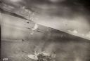
| Date: | 10 22 1943 |
|---|---|
| Description: | View across water of Mushu Island in the distance. There is a ship in the foreground, an airplane above, and the appearance of explosions in the water. |

| Date: | |
|---|---|
| Description: | Hand-drawn map of the area at the time of Pilgrim landing, drawn by Charles Blaskowikz. Includes commemorative historical notes. |
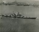
| Date: | 10 23 1945 |
|---|---|
| Description: | Aerial view of U.S.S. Wisconsin (BB-64) in San Francisco Bay. Several boats can be seen in the water near the ship and San Francisco is visible in t... |

| Date: | |
|---|---|
| Description: | Bird's-eye view lithograph of Key West with ships and smaller boats in the surrounding waters. |

| Date: | 1959 |
|---|---|
| Description: | Aerial view of the island of Cuba taken from a small plane. Part of the plane with a Cuban flag painted on it is in the frame, and the island with many bui... |

| Date: | 1945 |
|---|---|
| Description: | Leota Kelly, director of the Red Cross's Pacific Athletic Club, posing for a picture by the shore in Tinian at the site of the new Red Cross Club. Kelly is... |

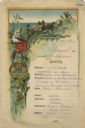
| Date: | 07 21 1925 |
|---|---|
| Description: | Dinner menu from the Hotel St. Catherine, with a color postcard at the top, meant to be detached and mailed, with a view of the hotel against a backdrop of... |

| Date: | 1720 |
|---|---|
| Description: | Double hemispherical world map showing routes of Tasman, Magellan, Mendana, etc. Relief shown pictorially. Title in oak wreath cartouche. Map between four ... |

| Date: | 1798 |
|---|---|
| Description: | Engraved and hand-colored map of Egypt. Map title appears on bottom left as a carving in stone next ... |

| Date: | |
|---|---|
| Description: | Front cover and partial menu listing with drinks overleaf. Front cover has a porthole view of pairs of men in three boats with mountains and palm trees in ... |
| Date: | 08 09 1890 |
|---|---|
| Description: | One-page menu from the R.M.S.S. Magdalena of the Royal Mail Steam Packet Company, with a parrot and a cockatiel perched on a branch above the compan... |

| Date: | 03 24 1950 |
|---|---|
| Description: | Front cover of a farewell dinner menu from the Italian Line ship Saturnia, with two Commedia dell' Arte characters: Tartaglia, a rotund figure who w... |

| Date: | |
|---|---|
| Description: | Letterhead of Johnson & Melaas, merchant tailors and cloth dealers, "Buyers of wool and Wisconsin leaf tobacco," with an engraving of a waterfront view of ... |
| Date: | 1950 |
|---|---|
| Description: | Export map for International Harvester products manufactured in Australia at the company's Geelong and Dandenong Works. |

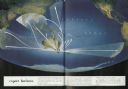
| Date: | 1950 |
|---|---|
| Description: | Inside spread illustration of the world, with a legend indicating: Subsidiary Company, Branch of Subsidiary, Representative, Works, and Distributor. |

| Date: | 1942 |
|---|---|
| Description: | This pictorial bird's-eye-view map shows the United States of America with parts of Canada and Mexico. Landscape, trade, industry, points of interest, peop... |

| Date: | 1878 |
|---|---|
| Description: | This lithograph shows Greenland, North America, Central America, South America, Polynesia, Australia, the Pacific Ocean, the Atlantic Ocean, the Arctic Oce... |
If you didn't find the material you searched for, our Library Reference Staff can help.
Call our reference desk at 608-264-6535 or email us at: