 Filter: Categories of Wisconsin Historical Images
Filter: Subject of Ocean
Filter: Subject of harbors
Filter: Subject of botany
Filter: Categories of Wisconsin Historical Images
Filter: Subject of Ocean
Filter: Subject of harbors
Filter: Subject of botany
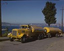
| Date: | 1951 |
|---|---|
| Description: | Color photograph of an International LD-400 series tanker truck owned by Eastern Washington Transports, Inc., on a road near the Port of Seattle. |
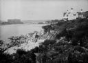
| Date: | 1930 |
|---|---|
| Description: | View along top of rocky cliff toward a home on the right overlooking the ocean, with a large building further down the curving shoreline in the distance. |
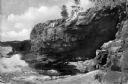
| Date: | 1940 |
|---|---|
| Description: | View of Anemone Cave and crashing waves, surrounded by coastal rock formations. |
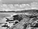
| Date: | 1925 |
|---|---|
| Description: | View along rocky coastline with crashing waves. Buildings are along the shoreline in the distance. Caption reads: "View from Ye Headland Inn. Trefethen, Ma... |
| Date: | 1920 |
|---|---|
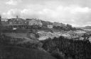
| Description: | View along top of cliff toward cottages along a rocky coast. A large building is in the distance on the right. |

| Date: | 1920 |
|---|---|
| Description: | View across harbor filled with boats toward small wooden cottages along the far shoreline. A rock wall along the water's edge is in the foreground on the r... |

| Date: | 1920 |
|---|---|
| Description: | A view of Yorks Island Harbor and lobster fishing boats in a cove. Caption reads: "Lobster Fleet at Yorks Island Harbor, Isle au Haut, Me." |

| Date: | |
|---|---|
| Description: | Elevated view of village homes on the shores of the bay with docked fishing boats in the foreground. Caption reads, "Marblehead, Mass from Rockmere Point." |

| Date: | |
|---|---|
| Description: | Bird's-eye view lithograph of Key West with ships and smaller boats in the surrounding waters. |

| Date: | |
|---|---|
| Description: | View of expansive gardens rolling down to a harbor. |

| Date: | 02 05 1944 |
|---|---|
| Description: | General view of Port Moresby Harbor from road, New Guinea (present day Papua New Guinea). A jeep is on the road on the left. Several soldiers are near a sh... |
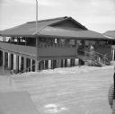
| Date: | 02 05 1944 |
|---|---|
| Description: | View from road of the exterior of the Allied Officers' Club in Port Moresby, New Guinea (present day Papua New Guinea). It is built on posts above the wate... |

| Date: | 1715 |
|---|---|
| Description: | One of Herman Moll's most famous maps, often referred to as The Codfish Map, it shows rivers and portages, cities, Indian villages, wind directions, routes... |
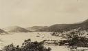
| Date: | 03 1913 |
|---|---|
| Description: | Elevated view of the harbor at Charlotte Amalie, St. Thomas. Sailing vessels of various sizes are moored in the harbor. There are islands in the background... |

| Date: | 1935 |
|---|---|
| Description: | Elevated view of men, women and children ready to disembark ship. Original caption reads: "Determination to make good is written on the faces of the Wiscon... |
If you didn't find the material you searched for, our Library Reference Staff can help.
Call our reference desk at 608-264-6535 or email us at:
