 Filter: Categories of Wisconsin Historical Images
Filter: Subject of Ocean
Filter: Subject of fishes
Filter: Categories of Wisconsin Historical Images
Filter: Subject of Ocean
Filter: Subject of fishes
| Date: | |
|---|---|
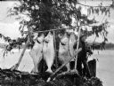
| Description: | A fishermen smoking a pipe poses with fish strung from a wooden pole beneath an evergreen tree. |
| Date: | |
|---|---|
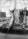
| Description: | Fishermen and women pose with a swordfish tied to a mast aboard a boat. |
| Date: | 12 1942 |
|---|---|
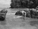
| Description: | Olive Brooks, Division Engineer Public Relations, collecting dead fish after throwing dynamite into the water. She is holding a fish and has her pants roll... |
| Date: | 02 02 1951 |
|---|---|
| Description: | Front cover of the menu and program for the Fifth Anniversary of the Secretary-Generalship of Trygve Lie, first Secretary-General of the United Nations (UN... |

| Date: | 07 21 1925 |
|---|---|
| Description: | Dinner menu from the Hotel St. Catherine, with a color postcard at the top, meant to be detached and mailed, with a view of the hotel against a backdrop of... |

| Date: | 1946 |
|---|---|
| Description: | This bird's-eye-view map shows scenes of land use and farming superimposed on a map of the United States. Agricultural scenes of farming, livestock, and cr... |

| Date: | 1715 |
|---|---|
| Description: | One of Herman Moll's most famous maps, often referred to as The Codfish Map, it shows rivers and portages, cities, Indian villages, wind directions, routes... |

| Date: | 1746 |
|---|---|
| Description: | Map of North America from the southern portion of James Bay to Florida. It shows the colonies, cities, Native American land, and topological and geographic... |

| Date: | 1760 |
|---|---|
| Description: | Map of North America based upon the cartographic work of de L'Isle. It shows cities, regions, lakes, rivers, Native American land, mountains, islands, and ... |
If you didn't find the material you searched for, our Library Reference Staff can help.
Call our reference desk at 608-264-6535 or email us at: