 Filter: Categories of Wisconsin Historical Images
Filter: Subject of Ocean
Filter: Subject of dwellings
Filter: Categories of Wisconsin Historical Images
Filter: Subject of Ocean
Filter: Subject of dwellings
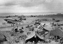
| Date: | 02 1945 |
|---|---|
| Description: | Iwo Jima Airfield #1, as it appeared nine days after the initial assault. On the runway is a C-47 transport plane, the military equivalent of the DC-3. T... |

| Date: | 1655 |
|---|---|
| Description: | Map from Drake Expedition, ca. 1585. |

| Date: | 1784 |
|---|---|
| Description: | Plate 57. Scene from Cook's Third Expedition, 1776-1779, while in Alaska. |
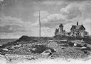
| Date: | |
|---|---|
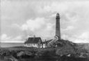
| Description: | Eastern Point Lighthouse at "Mother Ann" and residence on rocky point, Gloucester, Massachusetts. Mother Ann is a rocky cliff at the far south end of Easte... |
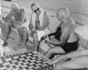
| Date: | 12 1951 |
|---|---|
| Description: | Philleo Nash (playing the guitar), Presidential adviser on Minority Affairs, entertains President Harry Truman (in the sunglasses), with folk songs during ... |
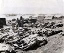
| Date: | 1945 |
|---|---|
| Description: | Marines, killed in action, lie on stretchers covered with ponchos on the beach at Iwo Jima. Four marines attend to the dead. Tents, military boats, and an ... |

| Date: | 1928 |
|---|---|
| Description: | An original lithograph promoting the S.S. Leviathan as the "World's Largest Ship." The poster depicts an elevated view of a large number of tourists... |

| Date: | |
|---|---|
| Description: | View of the beach in front of the Hotel Clarendon, featuring swimmers, benches, and shade-structures made with palm leaves. |
| Date: | |
|---|---|
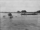
| Description: | View across water toward the shore. People are rowing a boat in the foreground, and people are standing on a rock near the shore. In the background are hou... |
| Date: | |
|---|---|
| Description: | Elevated view of an oceanfront residence, featuring a modern flat-roofed structure. |
| Date: | 1908 |
|---|---|
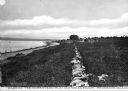
| Description: | A view of a shoreline. Caption reads: "Part of the homestead plat and waterfront. Prudence Island." Along the left is a rock wall, and a house in the dista... |
| Date: | 1930 |
|---|---|
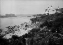
| Description: | View along top of rocky cliff toward a home on the right overlooking the ocean, with a large building further down the curving shoreline in the distance. |
| Date: | 1920 |
|---|---|
| Description: | View along top of cliff toward cottages along a rocky coast. A large building is in the distance on the right. |

| Date: | 1920 |
|---|---|
| Description: | View across harbor filled with boats toward small wooden cottages along the far shoreline. A rock wall along the water's edge is in the foreground on the r... |
| Date: | 1920 |
|---|---|
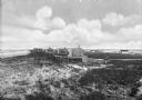
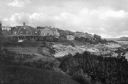
| Description: | Elevated view from hill looking down toward buildings in the hills along the coast. |

| Date: | |
|---|---|
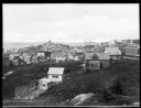
| Description: | Elevated view of village homes on the shores of the bay with docked fishing boats in the foreground. Caption reads, "Marblehead, Mass from Rockmere Point." |

| Date: | |
|---|---|
| Description: | Residence of Charles A. Angells. The coastline is in the background. |
| Date: | 1918 |
|---|---|
| Description: | View across rocks toward the Mount Desert Rock granite lighthouse, established in 1830 and automated in 1977, located thirty miles out to sea on a treeless... |
| Date: | |
|---|---|
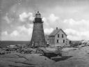
| Description: | View across rocky ground and grass toward the Northern Lighthouse and the nearby cottage. A covered walkway leads from the house up to the entrance of the ... |
| Date: | |
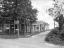
|---|---|
| Description: | View from unpaved road toward houses down a side dirt road leading toward a beach in the background. A man stands on the porch of the house in the left for... |
If you didn't find the material you searched for, our Library Reference Staff can help.
Call our reference desk at 608-264-6535 or email us at: