 Filter: Categories of Wisconsin Historical Images
Filter: Subject of Ocean
Filter: Subject of cities and towns
Filter: Subject of civil war, 1861-1865
Filter: Categories of Wisconsin Historical Images
Filter: Subject of Ocean
Filter: Subject of cities and towns
Filter: Subject of civil war, 1861-1865

| Date: | 1861 |
|---|---|
| Description: | A general map of Pennsylvania, Virginia, New Jersey and Delaware. Insets include maps of New Orleans, Baltimore, St. Louis, Charleston, Savannah, Washingto... |

| Date: | 1862 |
|---|---|
| Description: | This map of the southeastern United States shows cities and towns, rail lines, and geographic features such as rivers, mountains, lakes, and swamps. |

| Date: | 1862 |
|---|---|
| Description: | This map of the southeastern United States shows forts and battlefields, railroads, rivers, and cities and towns. Dates of admission and secession of the s... |

| Date: | 1863 |
|---|---|
| Description: | A general map of the southeastern United States showing Missouri, Kentucky, West Virginia, Virginia, North Carolina, South Carolina, Georgia, Florida, Alab... |
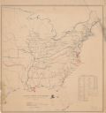
| Date: | |
|---|---|
| Description: | Map of the eastern United States that illustrates the limits of the "loyal states" as of July 1861 in red, the territory controlled by United States forces... |

| Date: | 1864 |
|---|---|
| Description: | A map of Sherman's March from Atlanta, Georgia to Goldsboro, North Carolina. |
If you didn't find the material you searched for, our Library Reference Staff can help.
Call our reference desk at 608-264-6535 or email us at: