 Filter: Categories of Wisconsin Historical Images
Filter: Subject of Neighborhoods
Filter: Subject of trees
Filter: Subject of intellectual life
Filter: Categories of Wisconsin Historical Images
Filter: Subject of Neighborhoods
Filter: Subject of trees
Filter: Subject of intellectual life

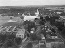
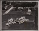
| Date: | 1908 |
|---|---|
| Description: | Aerial view of Camp Randall Field on the University of Wisconsin-Madison campus. University Heights is in the background. |

| Date: | 1956 |
|---|---|
| Description: | Aerial view of the Chicago, Milwaukee, and St. Paul Railroad station, roundhouse, and yard at the intersection of West Washington Avenue (across lower left... |
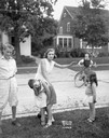
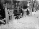
| Date: | 08 27 1931 |
|---|---|
| Description: | Virginia Gillette demonstrates how residents in the 400 block of Virginia Terrace are combating traffic dangers by spanking. Dicky Dupois is over her knee,... |

| Date: | 08 04 1930 |
|---|---|
| Description: | Men inspecting automobiles in the "Safety Lane" on Wisconsin Avenue, sponsored by American Automobile Association (AAA). |
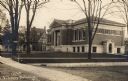
| Date: | 1910 |
|---|---|
| Description: | Exterior of library with unfinished landscaping. Houses are further down the street on the left. A sign attached to a tree reads: "S Fourth St." Caption re... |

| Date: | 1930 |
|---|---|
| Description: | Aerial view of city, with Eau Claire River is in the foreground with Milwaukee railroad bridge at left. Gillette Rubber Co. plant is in center with Omaha r... |
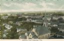
| Date: | |
|---|---|
| Description: | View of the town with a church in the foreground. Caption reads: "Birdseye View, Edgerton, Wis." |
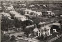
| Date: | 1945 |
|---|---|
| Description: | Aerial view of Madison over the University Avenue-Randall Stadium area, looking toward the Congregationalist Church and the U.S. Forest Products Laboratory... |

| Date: | 1955 |
|---|---|
| Description: | Aerial view of Atwood Avenue, looking west towards Winnebago Street and "Schenk's Corners." |

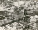
| Date: | 1953 |
|---|---|
| Description: | Aerial view looking southeast over Madison's near east side. The Eagles Club at 1236 Jenifer Street / 1221 Williamson Street is under construction in the ... |

| Date: | 07 24 1952 |
|---|---|
| Description: | Aerial view of the Wisconsin State Fair grounds, showing the GMC trucks tent and the residential neighborhood that bordered the grounds. |

| Date: | 11 1928 |
|---|---|
| Description: | Aerial view of Verona including businesses, houses, and the surrounding farm land. |

| Date: | 11 1928 |
|---|---|
| Description: | Aerial view of Black Earth residential area and the surrounding countryside. |

| Date: | 1953 |
|---|---|
| Description: | Aerial view of Wonewoc with hills or bluffs in the foreground on the right. |

| Date: | 1930 |
|---|---|
| Description: | Aerial view of Tenney Park, including the lagoon, residences surrounding the park, and the shoreline of Lake Mendota on bottom left. |
| Date: | 1865 |
|---|---|
| Description: | Aerial view of a residential part of Janesville. |
| Date: | 12 22 1956 |
|---|---|
| Description: | Home of Norman and Ruth Bass, 4216 Mandrake Road, winner of the Christmas outdoor home lighting contest. |
| Date: | 1925 |
|---|---|
| Description: | Aerial view of a neighborhood in Merrill. |
| Date: | 1954 |
|---|---|
| Description: | Aerial view of the Gonstead residence, owned by a well-known chiropractor and designed by Herb Fritz, architect, a student of Frank Lloyd Wright. |

| Date: | 02 06 1948 |
|---|---|
| Description: | Aerial photograph of Madison's west side looking northeast along Speedway Road. Visible are Forest Hill and Resurrection Cemeteries, West High School, Hoyt... |
If you didn't find the material you searched for, our Library Reference Staff can help.
Call our reference desk at 608-264-6535 or email us at: