 Filter: Categories of Wisconsin Historical Images
Filter: Subject of Neighborhoods
Filter: Subject of railroads
Filter: Categories of Wisconsin Historical Images
Filter: Subject of Neighborhoods
Filter: Subject of railroads
| Date: | |
|---|---|
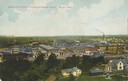
| Description: | Elevated view of the plant and residential area, with smokestacks. Caption reads: "Birds-eye View of Fairbanks Morse Plant, Beloit, Wis." |

| Date: | 1953 |
|---|---|
| Description: | An aerial view of Wonewoc showing central businesses and a railroad. |
| Date: | 1961 |
|---|---|
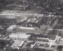
| Description: | Aerial view of the Miller Electic Manufacturing Co. and surrounding area. |

| Date: | 1878 |
|---|---|
| Description: | This map shows block numbers, wards, roads, railroads, parks, and selected buildings and includes a "Milwaukee city street guide" as well as a guide to pub... |

| Date: | 1887 |
|---|---|
| Description: | This map shows block numbers, roads, railroads, wards, and selected buildings. The map includes a "Milwaukee city street guide" and index to public buildin... |
| Date: | 07 24 1906 |
|---|---|
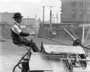
| Description: | Right side view of a man sitting on a Milwaukee No. 12 Harvester and Binder (grain binder). In the background are men standing by a large metal gate and ra... |

| Date: | 1860 |
|---|---|
| Description: | Map shows meadows, forests, buildings, railroad, and lots south of part of the city of Milwaukee. Relief shown by hachures. Includes list of lot acreages. |

| Date: | 1954 |
|---|---|
| Description: | This map of La Crosse shows residential, multiple dwelling, local business, commercial, light industrial, heavy industrial and special multiple dwelling la... |

| Date: | 1888 |
|---|---|
| Description: | This map has relief shown by hachures and features inset maps of a plat of E.D. Clinton and Blackwell’s add’n to the City of La Crosse. Wards (1-10) shaded... |

| Date: | 1896 |
|---|---|
| Description: | This map shows a plat of the town, wards, buildings, the state capitol, local streets, railroads, and parts of Lake Mendota, Lake Monona, and Lake Wingra. ... |

| Date: | 1857 |
|---|---|
| Description: | This map shows lot and block numbers, wards, roads, railroads, some landowners’ names, and selected buildings. Lake Michigan, the Milwaukee River, and Glid... |

| Date: | 1857 |
|---|---|
| Description: | This map shows lot and block numbers, wards, roads, railroads, some landowners’ names, and selected buildings. Lake Michigan, the Milwaukee River, and Glid... |

| Date: | 1868 |
|---|---|
| Description: | This map shows lot and block numbers, some property ownership, wards, roads, and railroads. An inset map shows the Glidden & Lockwood’s addition. There are... |

| Date: | 1869 |
|---|---|
| Description: | This map shows lot and block numbers, some property ownership, wards, roads, and railroads and includes inset map of Glidden & Lockwood’s addition. There a... |

| Date: | 1846 |
|---|---|
| Description: | This map shows lot and block numbers, roads, railroads, and some landowners’ names and includes the manuscript annotations: "From the Lapham collection" --... |

| Date: | 1845 |
|---|---|
| Description: | This map shows lot and block numbers, local streets, railroads, some landowners’ names, Milwaukee River, Menomonee River, and part of Lake Michigan. The ma... |

| Date: | 1846 |
|---|---|
| Description: | This map shows lot and block numbers, local streets, railroads, some landowners’ names, Milwaukee River, Menomonee River, and part of Lake Michigan. The ma... |

| Date: | 1847 |
|---|---|
| Description: | This map shows lot and block numbers, roads, railroads, and some landowners’ names. Lake Michigan, the Milwaukee River, and the Menomonee River are labeled... |
If you didn't find the material you searched for, our Library Reference Staff can help.
Call our reference desk at 608-264-6535 or email us at:

