Filter: Categories of Wisconsin Historical Images
Filter: Subject of Neighborhoods
Filter: Subject of land use, urban
Filter: Categories of Wisconsin Historical Images
Filter: Subject of Neighborhoods
Filter: Subject of land use, urban
| Date: | 1916 |
|---|---|
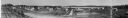
| Description: | Panoramic view of the Wingra area from the railroad tracks north of Gregory Street. Looking towards Lake Wingra, across Monroe Street. |
| Date: | |
|---|---|
| Description: | View of buildings from the dome of the Exposition building, including a church and the Best Brewing Company in the distance. |
| Date: | 11 24 1945 |
|---|---|
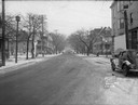
| Description: | 400 block of West Johnson Street looking west toward North Bassett Street showing Irven Krause Grocery and Market, 222 North Bassett Street and Erickson Te... |
| Date: | 11 24 1945 |
|---|---|
| Description: | Looking east on 500 block of West Johnson Street toward North Bassett Street showing Irven Krause Grocery and Market, 222 North Bassett Street and Erickson... |
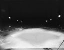
| Date: | 05 13 1931 |
|---|---|
| Description: | Elevated view of Breese Stevens Athletic Field illuminated at night. |
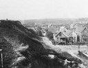
| Date: | 1925 |
|---|---|
| Description: | Elevated view from a hill of an alley connecting Park Hill Avenue and Mount Vernon Avenue, looking west from the Interurban Line. There is a person on top ... |
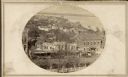
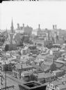
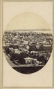
| Date: | 1859 |
|---|---|
| Description: | South Pinckney Street as photographed by Fuller from the Wisconsin State Capitol roof. In the center are several wooden structures dating from Madison's e... |

| Date: | |
|---|---|
| Description: | Elevated view of residences and university buildings made from the Soldiers' Orphan's Home (aka the "Farwell house"). Three University of Wisconsin-Madison... |

| Date: | |
|---|---|
| Description: | Residences on Big Bug Hill (Pinckney and Gilman streets). The image was taken from the corner of Webster or Butler Street and Mifflin Street. |

| Date: | |
|---|---|
| Description: | Orsamus Cole residence located at the corner of Pinckney and Gorham streets. Cole was a justice of the Wisconsin Supreme Court beginning about 1855. Three ... |

| Date: | |
|---|---|
| Description: | View of Madison from the Farwell Octagon House (Harvey Hospital/Soldier's Orphans Home). The third Wisconsin State Capitol building (second in Madison), is... |
| Date: | |
|---|---|
| Description: | Elevated view toward the County Courthouse from University Hall (now Bascom Hall) of the University of Wisconsin-Madison. The County Courthouse is in the u... |
| Date: | 1900 |
|---|---|
| Description: | Elevated view of Cassville and its residential area. Bottom text reads: "Souvenir, Cassville." Written at top right: "Cassvie Wis..... 190__." |

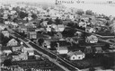
| Date: | 1930 |
|---|---|
| Description: | Aerial view of city, with Eau Claire River is in the foreground with Milwaukee railroad bridge at left. Gillette Rubber Co. plant is in center with Omaha r... |

| Date: | 1955 |
|---|---|
| Description: | Aerial view of Atwood Avenue, looking west towards Winnebago Street and "Schenk's Corners." |

| Date: | 1953 |
|---|---|
| Description: | Aerial view looking southeast over Madison's near east side. The Eagles Club at 1236 Jenifer Street / 1221 Williamson Street is under construction in the ... |
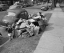
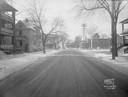
| Date: | 06 15 1948 |
|---|---|
| Description: | Uncollected garbage on South Hamilton Street being viewed by two children during a walkout strike by Local 236 Municipal Garage Department Union. |
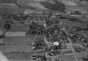
| Date: | 10 1928 |
|---|---|
| Description: | Aerial view of DeForest including residences and the surrounding countryside. |

| Date: | 11 1928 |
|---|---|
| Description: | Aerial view of Verona including businesses, houses, and the surrounding farm land. |
If you didn't find the material you searched for, our Library Reference Staff can help.
Call our reference desk at 608-264-6535 or email us at: