 Filter: Categories of Wisconsin Historical Images
Filter: Subject of Neighborhoods
Filter: Subject of harbors
Filter: Categories of Wisconsin Historical Images
Filter: Subject of Neighborhoods
Filter: Subject of harbors
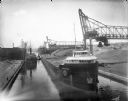
| Date: | 07 17 1914 |
|---|---|
| Description: | Menominee River coal yards, west from the 16th Street viaduct. There is a cargo ship called the "John B. Cowle" in the harbor between two coal yards. Worke... |
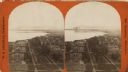
| Date: | 1876 |
|---|---|
| Description: | Stereograph. Elevated view looking roughly south, the foreground overlooks a residential neighborhood. On the far shoreline, smoke clouds spew out from lar... |

| Date: | 1937 |
|---|---|
| Description: | This is map 1 from a set of 4 taken from an atlas. The map shows streets, neighborhoods and proposed subdivision. Lake Michigan, Algoma Outer Harbor, the A... |

| Date: | 1926 |
|---|---|
| Description: | This blueprint map shows the land and its uses near Two Rivers Harbor. Lake Michigan is labeled on the left. Roads and buildings are also labeled. Original... |

| Date: | 1989 |
|---|---|
| Description: | This color coded map shows the various rivers, lakes, bays, and islands that make up the harbor. It includes an index of industries (maritime and non-marit... |

| Date: | 1922 |
|---|---|
| Description: | Text on front reads: "Aerial View of Sheboygan, Wis." The image shows the Sheboygan River from Lake Michigan to the Pennsylvania Avenue bridge. |

| Date: | 1916 |
|---|---|
| Description: | Text on front reads: "North Point — Sheboygan, Wis." Elevated view of a Niagara limestone shelf of rock that rises above Lake Michigan. This rarely occurs ... |
If you didn't find the material you searched for, our Library Reference Staff can help.
Call our reference desk at 608-264-6535 or email us at: