 Filter: Categories of Wisconsin Historical Images
Filter: Subject of Neighborhoods
Filter: County of Milwaukee
Filter: Categories of Wisconsin Historical Images
Filter: Subject of Neighborhoods
Filter: County of Milwaukee

| Date: | |
|---|---|
| Description: | Vel Phillips grips the bat and ducks as the ball is pitched at a baseball game. The catcher is on the right. Chain link fencing, a bicycle and a residentia... |

| Date: | 1860 |
|---|---|
| Description: | Map shows meadows, forests, buildings, railroad, and lots south of part of the city of Milwaukee. Relief shown by hachures. Includes list of lot acreages. |

| Date: | 03 03 1937 |
|---|---|
| Description: | A pencil drawing of a proposed area of the planned community of Greendale, Wisconsin. The community was established as an objective of the Department of Ag... |

| Date: | 09 23 1959 |
|---|---|
| Description: | Outdoor news portrait of Timothy Vick of 3957 North 63rd Street, Milwaukee. News photo made in connection with a murder case; the murderer, going door-to-d... |

| Date: | 1932 |
|---|---|
| Description: | This map of Granville shows streets, businesses, residential areas, schools, golf courses, and industrial areas. The map shows Granville in March of 1932. ... |
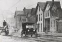
| Date: | 1918 |
|---|---|
| Description: | Street view of the north side of State Street, west of 6th Street. The second frame house from the right was once occupied as an office by Victor L. Berger... |

| Date: | 1957 |
|---|---|
| Description: | Residential street with three boys playing “soldier”. |

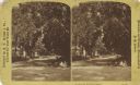
| Date: | 1963 |
|---|---|
| Description: | Detail view along front porches of frame residences. |
| Date: | 1885 |
|---|---|
| Description: | View along Van Buren Street, looking north from Mason Street. Three children are sitting on the curb at the corner. |
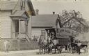
| Date: | |
|---|---|
| Description: | View from the street of John Hahn standing on the right with a horse hitched to a passenger wagon. In the center is the furniture moving wagon he owns, in ... |
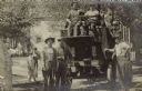
| Date: | 1906 |
|---|---|
| Description: | John Hahn is leaning on a motorized moving van in the S. Sixth Street neighborhood of Walker's Point. At the steering wheel is a man, with another seated n... |
| Date: | |
|---|---|
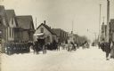
| Description: | View down a snowy street. Men and women, one with a baby, are bundled up against the snowy winter weather, and are lining both sides of the street. Carriag... |
| Date: | |
|---|---|
| Description: | An elaborate funeral hearse is pulled up to a house with the back doors open, waiting to be loaded with the casket. There are many men and women bundled up... |

| Date: | |
|---|---|
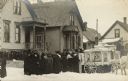
| Description: | Group portrait of neighborhood children and adults gathered on a street in the S. Sixth Street neighborhood of Walker's Point that is being re-paved. Many ... |

| Date: | |
|---|---|
| Description: | A young baseball player poses outside the porch of his S. Sixth St. Walker's Point neighborhood home. He is wearing a baseball uniform with cap, and is hol... |

| Date: | 1908 |
|---|---|
| Description: | View from the street of three people standing in front of a small house. There is a small Oeil-de-boeuf window in the upper story. The windows have shutter... |

| Date: | 1857 |
|---|---|
| Description: | This map shows lot and block numbers, wards, roads, railroads, some landowners’ names, and selected buildings. Lake Michigan, the Milwaukee River, and Glid... |

| Date: | 1857 |
|---|---|
| Description: | This map shows lot and block numbers, wards, roads, railroads, some landowners’ names, and selected buildings. Lake Michigan, the Milwaukee River, and Glid... |

| Date: | 1868 |
|---|---|
| Description: | This map shows lot and block numbers, some property ownership, wards, roads, and railroads. An inset map shows the Glidden & Lockwood’s addition. There are... |

| Date: | 1869 |
|---|---|
| Description: | This map shows lot and block numbers, some property ownership, wards, roads, and railroads and includes inset map of Glidden & Lockwood’s addition. There a... |
If you didn't find the material you searched for, our Library Reference Staff can help.
Call our reference desk at 608-264-6535 or email us at: