 Filter: Categories of Wisconsin Historical Images
Filter: Subject of Neighborhoods
Filter: County of Dane
Filter: Year of 1800-1899
Filter: Type of Map or Atlas
Filter: Categories of Wisconsin Historical Images
Filter: Subject of Neighborhoods
Filter: County of Dane
Filter: Year of 1800-1899
Filter: Type of Map or Atlas
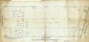
| Date: | 09 1886 |
|---|---|
| Description: | This map shows buildings with dimensions, as well as lot and block corners. Ink on tracing cloth. Oriented with north to the lower right. |

| Date: | 1885 |
|---|---|
| Description: | A detail of a Sanborn map showing the lake Mendota shore area, including Madison Manufacturing Company. |

| Date: | 10 1898 |
|---|---|
| Description: | A detail of a Sanborn map including Lake Front and Lake Lawn areas by Langdon Street. |

| Date: | 1896 |
|---|---|
| Description: | This map shows a plat of the town, wards, buildings, the state capitol, local streets, railroads, and parts of Lake Mendota, Lake Monona, and Lake Wingra. ... |

| Date: | 1890 |
|---|---|
| Description: | Plat map of Madison, T7N R9E, including portions of the towns of Blooming Grove and Burke. Includes inset maps of South Madison, Quarrytown, Marril Park, a... |
If you didn't find the material you searched for, our Library Reference Staff can help.
Call our reference desk at 608-264-6535 or email us at: