 Filter: Categories of Wisconsin Historical Images
Filter: Subject of Neighborhoods
Filter: County of Dane
Filter: Subject of landscape
Filter: Categories of Wisconsin Historical Images
Filter: Subject of Neighborhoods
Filter: County of Dane
Filter: Subject of landscape
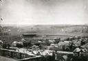
| Date: | 1906 |
|---|---|
| Description: | Elevated view of Camp Randall Field from the top of Bascom Hall, with University Heights in the background. A crowd is in the stands at the stadium, and a ... |

| Date: | 11 19 1970 |
|---|---|
| Description: | Exterior view of the uniquely designed house of Byron Bloomfield at 1010 Edgehill Drive in Shorewood Hills, which is built into the side of a sharp slope. ... |
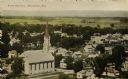
| Date: | 1907 |
|---|---|
| Description: | Elevated view of church and town. Caption reads: "Bird's-Eye View, Mazomanie, Wis." |
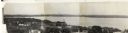
| Date: | 1930 |
|---|---|
| Description: | Panoramic elevated view to the east from the Capitol Square. |

| Date: | 1905 |
|---|---|
| Description: | View of Madison in the far distance taken from the third floor of a home at 216 Campbell Street, in University Heights. There is a power line suspended in ... |

| Date: | 1918 |
|---|---|
| Description: | This is a collection of two maps. One map is blue line print that includes illustrations and shows the location of buildings, gardens, plant life, and spri... |

| Date: | |
|---|---|
| Description: | Slightly elevated view over fields of the University of Wisconsin-Madison, showing, from right, Bascom Hall, the Observatory, and King Hall (1525 Observato... |

| Date: | |
|---|---|
| Description: | View across field towards structures in front of the Madison-Kipp Corporation building, pictured in the background. Its smokestack is visible to the right ... |
If you didn't find the material you searched for, our Library Reference Staff can help.
Call our reference desk at 608-264-6535 or email us at: