 Filter: Categories of Wisconsin Historical Images
Filter: Subject of Municipal services
Filter: County of Milwaukee
Filter: Creator Name of Unknown
Filter: Categories of Wisconsin Historical Images
Filter: Subject of Municipal services
Filter: County of Milwaukee
Filter: Creator Name of Unknown

| Date: | 1950 |
|---|---|
| Description: | Harbor area of Jones Island and garbage disposal plant, Stratton Grain Co., and more. |
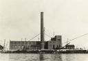
| Date: | 1924 |
|---|---|
| Description: | The smokestack is several inches out of plumb, which was the reason the photographer took the photograph. Located on a waterfront. |
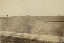
| Date: | 1900 |
|---|---|
| Description: | Reservoir, looking South, with pedestrians walking along the edge of the empty reservoir. A team of horses with a cart or wagon can also be seen in the bac... |
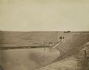
| Date: | 1900 |
|---|---|
| Description: | Looking down into the reservoir partially filled with water. A group of men stand at various levels; some with the carriage and horses at top, four on a le... |
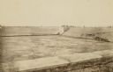
| Date: | 1900 |
|---|---|
| Description: | Several men are standing on top of a square ledge over the reservoir. Other men are working in the reservoir. On the right is a wooden walkway. |
| Date: | 1910 |
|---|---|
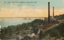
| Description: | Elevated view from hill toward the building which has two large smokestacks. The Lake Michigan shoreline is on the left. In front is a landscaped area with... |
| Date: | 1934 |
|---|---|
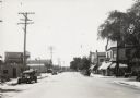
| Description: | View down road of overhead lighting equipment of the T.M.E.R. and L. Company, which, at the time had a proposal to be replaced by more modern lighting. Th... |
| Date: | 1934 |
|---|---|
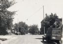
| Description: | Electrical overhead street light suspended above road. A truck is parked on the right, and houses and trees line both sides of the road. |
| Date: | |
|---|---|
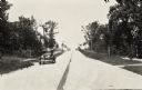
| Description: | View down road of lighting system using steel poles and modern fixtures on the terrace near sidewalks. Three cars are parked along the road, and houses are... |

| Date: | 1892 |
|---|---|
| Description: | This map shows water pipes, hydrants, stop cocks, check valves, fire cysterns, and manholes. Also shown are block numbers, streets, railroads, parks, cemet... |

| Date: | 1894 |
|---|---|
| Description: | This map shows sewers, intercepting sewers, manholes, block numbers, streets, railroads, parks, cemeteries, and Lake Michigan. The right margin reads: "Tot... |
If you didn't find the material you searched for, our Library Reference Staff can help.
Call our reference desk at 608-264-6535 or email us at: