 Filter: Categories of Wisconsin Historical Images
Filter: Subject of Municipal services
Filter: Community of Madison
Filter: Categories of Wisconsin Historical Images
Filter: Subject of Municipal services
Filter: Community of Madison
| Date: | 07 15 1952 |
|---|---|
| Description: | Group portrait of the Madison park commission crew, responsible for the construction of the starting ramp and finish line platform for the Madison Soap Box... |
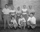
| Date: | 07 20 1952 |
|---|---|
| Description: | Group portrait of nine Madison street department workers who have prepared the derby hill for the Soap Box Derby for the past seven years. Kneeling, left t... |
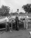
| Date: | 07 17 1953 |
|---|---|
| Description: | Four members of the Madison Parks Department building the ramp on Midvale Avenue for the upcoming Madison Soap Box derby. Left to right: Vie Cramer, Don Ke... |

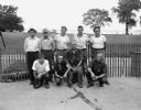
| Date: | 07 17 1953 |
|---|---|
| Description: | Seven Madison street department workers preparing the route of the upcoming Madison Soap Box derby. Left to right: Clark Evarts, William Skolaski, Ed Westb... |
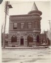
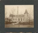
| Date: | 1900 |
|---|---|
| Description: | A man walks by the Madison police station, a two-story brick building with corner turret on the corner of South Webster Street. The fire station was across... |
| Date: | 1910 |
|---|---|
| Description: | The Madison waterworks building, with corner tower and turret. The building was located at the corner of Gorham and Livingston Streets. The large smokesta... |
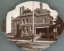
| Date: | 1905 |
|---|---|
| Description: | The Dane County sheriff's residence, with the county jail behind. A corner of the Dane County Court House is seen on the far left. |

| Date: | 07 22 1954 |
|---|---|
| Description: | City parks personnel, left to right: Carl J. Schultz, Herbert Gorman, Daniel Finn and Richard Gilliard put up the starting ramp on South Midvale Boulevard ... |

| Date: | 07 22 1954 |
|---|---|
| Description: | Outdoor group portrait of city streets department personnel Vincent Mongold (left), Gene Westbury, and Tony Cardarello Jr. The men helped set up the race t... |

| Date: | 10 20 1954 |
|---|---|
| Description: | Governor Walter Kohler being is presented with a 147-foot petition bearing signatures of 5,000 area residents seeking to ban the diversion of sewage from t... |

| Date: | 10 25 1957 |
|---|---|
| Description: | Six officials pose for a group portrait at the dedication of a playground structure made of concrete in the shape of a castle; it is sponsored by the Jayce... |

| Date: | 03 14 1958 |
|---|---|
| Description: | Elevated view of 13 firemen sitting at two tables, ready to eat their 11 am meal. The men are at Central Station at 18 South Webster Street. From left to ... |
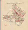
| Date: | 1916 |
|---|---|
| Description: | Shows streetlights, streets improvements, and sewer districts in red. Points of interest are labelled. Map reads: "Map of Tenth Ward Showing Improvements S... |

| Date: | 1880 |
|---|---|
| Description: | This map is pen-and-ink on paper. The map shows buildings, trees, and water and gas pipes, relief is shown by contours. The back of the map reads: "Univers... |

| Date: | 1887 |
|---|---|
| Description: | Shows pipes of various sizes, hydrants with hydrant pressure, valves, wells, and projected lines. |

| Date: | 1892 |
|---|---|
| Description: | Shows pipes of various sizes, hydrants with hydrant pressure, valves, wells, and projected lines. Differs from earlier versions by inclusion of Wingra Park... |

| Date: | 1896 |
|---|---|
| Description: | Shows pipes of various sizes, hydrants with hydrant pressure, valves, wells, projected lines, and suction pipes. Differs from earlier versions by inclusion... |

| Date: | 1903 |
|---|---|
| Description: | This map is ink on printed paper reading: "standard profile plate." "Surveyed Oct. 15, platted Dec. 15, 1903 ; surveyed May 9, platted Dec. 9." |

| Date: | 1908 |
|---|---|
| Description: | Shows pipes of various sizes, hydrants, valves, and wells. "1907" -- Lower margin. Lake Wingra, Lake Monona, and Lake Mendota are labelled. |
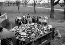
| Date: | 04 17 1959 |
|---|---|
| Description: | Thirty-three Sun Prairie 4-H youngsters are shown with one of four truckloads of trash they picked up along area highways. |
If you didn't find the material you searched for, our Library Reference Staff can help.
Call our reference desk at 608-264-6535 or email us at: