 Filter: Categories of Wisconsin Historical Images
Filter: Subject of Mountains
Filter: Creator Name of Unknown
Filter: Categories of Wisconsin Historical Images
Filter: Subject of Mountains
Filter: Creator Name of Unknown

| Date: | 1800 |
|---|---|
| Description: | Map of the United States. It shows the states, including Tennessee, cities, towns, Native American land, mountains, lakes, and rivers. Lead mines appear ju... |

| Date: | 1781 |
|---|---|
| Description: | Map of New Hampshire and surrounding regions. It shows borders, regions, cities, numerous forts, the country of the Iroquois, mountains, rivers, and lakes.... |

| Date: | 1775 |
|---|---|
| Description: | Map of Boston and surrounding regions, from Massachusetts Bay to the Connecticut River, and including part of southern New Hampshire. It shows the colonies... |

| Date: | 1780 |
|---|---|
| Description: | Map of eastern Massachusetts, Rhode Island, eastern Connecticut, and small portions of New Hampshire and Vermont. It shows the boundaries, counties, citie... |

| Date: | 1780 |
|---|---|
| Description: | Map of Connecticut, Rhode Island, and Long Island. it shows the borders, cities, roads, islands, mountains, lakes and rivers. Navigational hazards along th... |

| Date: | 1780 |
|---|---|
| Description: | Map of New York and parts of the neighboring states. It shows cities, forts, towns, roads, mountains, lakes, and rivers. several different boundary lines a... |

| Date: | 1780 |
|---|---|
| Description: | Map of Maryland and a portion of the surrounding provinces. It shows the boundary lines and borders, counties, cities, towns, roads, mountains, bays, and r... |

| Date: | 1675 |
|---|---|
| Description: | Map of the southeast coast of North America from Jamestown to modern Georgia. It shows European settlements, Native American land and villages, coastal fea... |

| Date: | 1779 |
|---|---|
| Description: | Map of North Carolina showing counties, cities, towns, chapels, courthouses, Quaker meeting houses, forts, mountains, swamps, inlets, lakes, and rivers. A ... |

| Date: | 1779 |
|---|---|
| Description: | Map of South Carolina showing boundary lines, Native American land, precincts, townships, cities, towns, forts, roads, mountains, hills, swamps, islands, a... |

| Date: | 1779 |
|---|---|
| Description: | Map of colonial Georgia showing cities, towns, Native American land and towns, forts, roads, trading paths, islands, mountains, swamps, and rivers. Annotat... |

| Date: | 1765 |
|---|---|
| Description: | Map showing the new British territories of East and West Florida following the Treaty of Paris at the end of the French and Indian War. It shows boundaries... |

| Date: | 1720 |
|---|---|
| Description: | Map showing the course of the Mississippi River from the Gulf of Mexico up past Lake Superior into Canada. It shows the towns, Native American tribes and l... |

| Date: | 1755 |
|---|---|
| Description: | Map of the Great Lakes region during the French and Indian War. It shows in great detail the territories, borders and boundary lines, Native American tribe... |
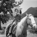
| Date: | |
|---|---|
| Description: | Outdoor publicity still of Pancho, actor Leo Carillo, sitting on horseback. He is posing with his arms crossed in front of his chest, and a bird (stuffed?)... |

| Date: | |
|---|---|
| Description: | Publicity photo of the Cisco Kid (Duncan Renaldo) and Pancho (Leo Carillo) standing next to their horses. They are both holding and pointing guns. |
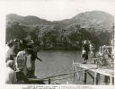
| Date: | |
|---|---|
| Description: | The cast and crew of the film "Gallant Lady" preparing to shoot a scene on a lake. The motion picture camera and crew are on a raft on the left, and are sh... |

| Date: | |
|---|---|
| Description: | Elevated view of the set of the film "Wuthering Heights." The crew is standing and sitting behind the camera which is on the ground. An actor and actress a... |

| Date: | |
|---|---|
| Description: | Workmen building a wooden walkway and platform around a cliff for the film "Wuthering Heights." |

| Date: | |
|---|---|
| Description: | The crew on the film "Wuthering Heights" shooting a scene with an actress on a cliff. The camera is on the left with two large lights, and two men holding ... |
If you didn't find the material you searched for, our Library Reference Staff can help.
Call our reference desk at 608-264-6535 or email us at: