Filter: Categories of Wisconsin Historical Images
Filter: Subject of Mounds
Filter: Year of 1900-1999
Filter: Year of 1900-1909
Filter: Categories of Wisconsin Historical Images
Filter: Subject of Mounds
Filter: Year of 1900-1999
Filter: Year of 1900-1909
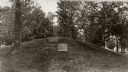
| Date: | 08 1905 |
|---|---|
| Description: | A visitor takes in the sight of three linear burial mounds at the Sure-Johnson mound group south of McFarland, Wisconsin. |
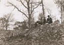
| Date: | 1908 |
|---|---|
| Description: | View looking up towards Reverend F.M. Gilmore, Professor W.E. Leonard, and Charles Brown relaxing on a burial mound on Fox Bluff near Lake Mendota. |
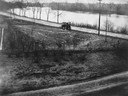
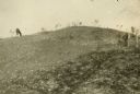
| Date: | 1905 |
|---|---|
| Description: | View of an Indian intaglio effigy, the only one still in existence in Wisconsin. The effigy is in the shape of a panther. There is a car on the road in the... |
| Date: | 1909 |
|---|---|
| Description: | A horse grazes near Native American burial mounds on the Dividing Ridge, a recessional moraine, between Lakes Monona and Wingra in Madison, Wisconsin. The ... |

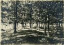
| Date: | 1908 |
|---|---|
| Description: | Children posing on a conical burial mound at Merrill Springs, on the south shore of Lake Mendota. (Also known as Merrill's Spring.) |
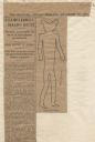
| Date: | 12 28 1906 |
|---|---|
| Description: | Newspaper article about the purchase of land for a park related to Man Mound in Sauk County accompanied by a line drawing of the mound. Article clipped fro... |

| Date: | 1903 |
|---|---|
| Description: | This maps shows what may be Ho Chunk Native American burial mounds. Also noted on the map is the Fox River, the Doty homestead, stockade embankment, the We... |
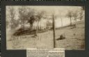
| Date: | 1905 |
|---|---|
| Description: | Two of a series of three large platform mounds on the top of a high hill, overlooking the Mississippi and Black River valleys. Two young children are seate... |
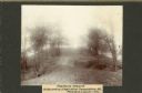
| Date: | 1905 |
|---|---|
| Description: | View across top of platform mound on the crest of a high hill. Trees are on the left and right. In the background below is the Mississippi River. |

| Date: | 1900 |
|---|---|
| Description: | This photocopy map shows marshes, woods, buildings, and selected features including islands, mounds, old Fort Crawford, and "new site for a fort in questio... |

| Date: | 05 26 1906 |
|---|---|
| Description: | The Wisconsin Archeological Society attending the unveiling of the Cutler Indian mound marker at Cutler Park. Mrs. William H. Anderson, President (?) of th... |

| Date: | 1901 |
|---|---|
| Description: | Plat map showing land ownership of Township 21N Range 3W in Jackson County for 1901. Scale is 2 inches to 1 mile. |

| Date: | 11 03 1903 |
|---|---|
| Description: | A drawing of a group of burial mounds in Linden Valley. Text on back reads: "These mounds lie at the narrow mouth of Linden Valley on the east side of the ... |
If you didn't find the material you searched for, our Library Reference Staff can help.
Call our reference desk at 608-264-6535 or email us at: