 Filter: Categories of Wisconsin Historical Images
Filter: Subject of Mounds
Filter: Year of 1800-1899
Filter: Categories of Wisconsin Historical Images
Filter: Subject of Mounds
Filter: Year of 1800-1899

| Date: | 1850 |
|---|---|
| Description: | Map showing Indian mounds and graves as well as ground cover types at Township 8, Range 22. There is an inset diagram of an effigy mound labeled "The Cross... |

| Date: | 1800 |
|---|---|
| Description: | An ink on paper map for a plan of mounds in Milwaukee county. The map is situated pointing north. |

| Date: | 1800 |
|---|---|
| Description: | This map on two sheets shows a group of ancient mounds near the southeast corner of the city of Beloit and a group of ancient mounds north of Rockton Stati... |

| Date: | 1873 |
|---|---|
| Description: | A map of the township of Primrose from the "Atlas of Dane County." |

| Date: | 1861 |
|---|---|
| Description: | This map shows townships and sections, landownership, roads, railroads, rural residences, schools, churches, and topography. Also included are inset maps o... |

| Date: | 1864 |
|---|---|
| Description: | This map is pen and watercolor on paper and shows a profile and geological sections of the Blue Mounds, Hollow Run, Bogies Hollow Run, Bear Creek, East Bre... |

| Date: | 1864 |
|---|---|
| Description: | This map is pen and watercolor on paper and shows a profile and geological sections of the East Blue Mound Break, Blue Mound Creek, Black Earth River, and ... |

| Date: | 1864 |
|---|---|
| Description: | This map is pen and watercolor on paper and shows a profile and geological sections of the Apple River, Little Otter Creek, Woods' Branch, Bonners' Branch,... |

| Date: | 1864 |
|---|---|
| Description: | This map is pen and watercolor on paper and shows a profile and geological sections of the Spensley Break, James Break, Wisconsin River, and Little Bear Cr... |

| Date: | 1864 |
|---|---|
| Description: | This map is pen and pencil on paper and shows a profile of the Blue Mound and East Blue Mound. |

| Date: | 1864 |
|---|---|
| Description: | This map is pen and pencil on paper and shows a profile of the Blue Mound and East Blue Mound. |

| Date: | 1864 |
|---|---|
| Description: | This map shows locations of quarries, sink holes, creeks, springs, rivers, houses, forts, and roads. Annotations in pencil read: "Is the top of the mound l... |

| Date: | 1850 |
|---|---|
| Description: | Diagrams of four effigy mounds surveyed by Increase A. Lapham and W.H. Canfield in 1850. No. 1 is an unidentified animal shape, No. 2 consists of two linea... |
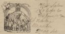
| Date: | 06 14 1862 |
|---|---|
| Description: | Letterhead featuring a scene of men and women raising their hands in the air. The two men in front are holding a sickle and the American flag, other people... |

| Date: | 1845 |
|---|---|
| Description: | Map of Wisconsin, including lower western border with Iowa, southern border along Illinois, eastern shoreline of Lake Michigan, and northern area along Wis... |
If you didn't find the material you searched for, our Library Reference Staff can help.
Call our reference desk at 608-264-6535 or email us at:
