Filter: Categories of Wisconsin Historical Images
Filter: Subject of Mounds
Filter: Subject of cities and towns
Filter: Categories of Wisconsin Historical Images
Filter: Subject of Mounds
Filter: Subject of cities and towns
| Date: | |
|---|---|
| Description: | A turtle effigy mound on the University of Wisconsin-Madison campus, outlined by melting snow. |
| Date: | |
|---|---|
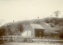
| Description: | View of large platform mound with small barn in the foreground. The numbers 1, 2, and 3 are written on the photograph in ink. |
| Date: | |
|---|---|
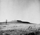
| Description: | View of the southwest pyramidal mound in Aztalan State Park as it appeared after restoration. A person is standing on top of the mound. |
| Date: | |
|---|---|
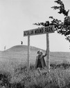
| Description: | Little girl under the "Aztalan Mound Park" sign, in a field. Another person stands in the background on one of the mounds. |
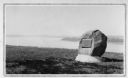
| Date: | 1920 |
|---|---|
| Description: | Historic site marker to commemorate Man Mound and to mark Man Mound Park. The inscription reads "Man Mound Park. Mound located and platted by W.H. Canfield... |
| Date: | |
|---|---|
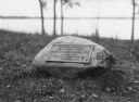
| Description: | View of a rock with a plaque that reads: "Group of Prehistoric Indian Burial Mounds and Winnebago Village Site. Marked by the Delavan Woman's Club - May 19... |
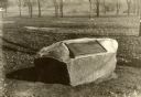
| Date: | 1930 |
|---|---|
| Description: | View of the panther itaglio effigy mound marker, located on Highway 106 West. The text on the marker reads: "Panther Intaglio Effigy; Panther Type, Length ... |

| Date: | 1936 |
|---|---|
| Description: | View of the panther intaglio effigy mound marker, located on Highway 106 West. The text on the marker reads: "Indian Intaglio Effigy; Panther Type, Length ... |
| Date: | 1930 |
|---|---|
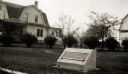
| Description: | View of an Indian mounds marker on the St. Croix River. |
| Date: | 1924 |
|---|---|
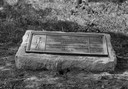
| Description: | A marker showing an Indian Mound in La Crosse. |

| Date: | 1935 |
|---|---|
| Description: | Members of the Wisconsin Outing Club watch the excavation of a burial mound at the Outlet group in 1935. |

| Date: | 1828 |
|---|---|
| Description: | Plat of the Private Claims at Prairie Du Chien. |

| Date: | |
|---|---|
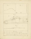
| Description: | Map of Baraboo and its surroundings, showing the ancient mound city, the water power, and thoroughfares, drawn by William H. Canfield. Canfield includes sk... |

| Date: | 04 12 1912 |
|---|---|
| Description: | Diagram of a bird effigy mound found in Frost's Woods, Blooming Grove Township. |

| Date: | 1892 |
|---|---|
| Description: | Topographical map of Madison and surrounding communities which include Lake Mendota, Lake Monona, Lake Waubesa and Lake Kegonsa. The red dots on the map sh... |

| Date: | 1892 |
|---|---|
| Description: | This map oriented with north to the upper left shows railroads, creeks, post offices, smaller lakes, Lake Mendota, Lake Monona, Lake Wingra, Lake Waubesa, ... |

| Date: | 1931 |
|---|---|
| Description: | This map of south central Wisconsin shows lakes, rivers, cities, villages, highways and roads, railroads, Indian mounds, and points of scenic and historic ... |

| Date: | 1866 |
|---|---|
| Description: | A map of Lafayette County, Wisconsin, showing the townships and ranges, sections, towns, villages, stream and rivers, mounds, mineral deposits and the Mine... |

| Date: | 1920 |
|---|---|
| Description: | This 1920 map actually depicts present-day Wyalusing State Park at the confluence of the Mississippi and Wisconsin rivers in the Town of Wyalusing, Grant C... |
If you didn't find the material you searched for, our Library Reference Staff can help.
Call our reference desk at 608-264-6535 or email us at: