Filter: Categories of Wisconsin Historical Images
Filter: Subject of Monuments
Filter: Year of 1800-1899
Filter: Year of 1880-1889
Filter: Categories of Wisconsin Historical Images
Filter: Subject of Monuments
Filter: Year of 1800-1899
Filter: Year of 1880-1889
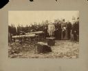
| Date: | 05 1887 |
|---|---|
| Description: | Members of the Wisconsin commission to locate monuments gather on the battlefield at Little Round Top. |
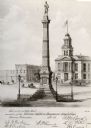
| Date: | 1884 |
|---|---|
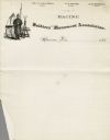
| Description: | Proposed Soldier's Monument illustration (erected in 1884) printed on a certificate of membership to the Racine Soldiers Monument Association. |

| Date: | 1885 |
|---|---|
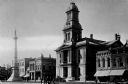
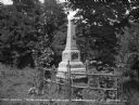
| Description: | Caption reads: "First Soldier's Monuments Erected in the US — Lancaster Wis". There is a cannon and cannon balls on the lawn to the left of the monuments. |
| Date: | 1887 |
|---|---|
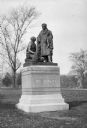
| Description: | Augustus Saint-Gaudens' monument to Abraham Lincoln, installed 1887. Image shows the bronze sculpture from its foot framed by young foliage in the backgro... |
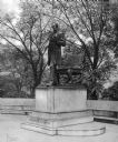
| Date: | 1888 |
|---|---|
| Description: | Close-up of a statue honoring Colonel Pierre Menard who also served as the Lieutenant Governor of Illinois and fur traded with Native Americans. Dedicated ... |
| Date: | 1889 |
|---|---|
| Description: | The grave marker of Tom Quick, Jr., who reputedly killed many Native Americans after he allegedly witnessed his father killed by a group of Native American... |

| Date: | 1880 |
|---|---|
| Description: | Interior view of Washington and Lee University chapel showing tomb of Robert E. Lee. Portraits hang on the wall around an arch leading to the tomb. |
| Date: | 1880 |
|---|---|
| Description: | Letterhead with an illustration of a soldier on guard duty in camp and the name of the associations' officers. |

| Date: | 1882 |
|---|---|
| Description: | Plat map of the village of Dunbarton, received by the Lafayette County Register's Office on September 22, 1892. Certification by the surveyor, Albert Pool,... |

| Date: | 1880 |
|---|---|
| Description: | This map shows wards, roads, railroads, lot and block numbers, subdivisions, parks, and some landownership. A handwritten annotation in red reads: "Note: S... |
If you didn't find the material you searched for, our Library Reference Staff can help.
Call our reference desk at 608-264-6535 or email us at: