 Filter: Categories of Wisconsin Historical Images
Filter: Subject of Mississippi River
Filter: Year of 1900-1999
Filter: Year of 1960-1969
Filter: Categories of Wisconsin Historical Images
Filter: Subject of Mississippi River
Filter: Year of 1900-1999
Filter: Year of 1960-1969

| Date: | 04 22 1965 |
|---|---|
| Description: | A panoramic view of the Mississippi River flooding during the spring, showing the dykes built along the Chicago, Burlington & Quincy Railroad tracks at Sec... |
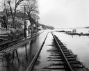
| Date: | 04 21 1965 |
|---|---|
| Description: | View down flooded railroad tracks of the Chicago, Burlington & Quincy Railroad by the Mississippi River. There are houses on the left, and in the backgroun... |

| Date: | 09 1962 |
|---|---|
| Description: | The Mississippi River along Highway 35. |
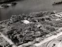
| Date: | 1960 |
|---|---|
| Description: | Aerial view of Villa Louis on the Mississippi River, and adjacent buildings. |
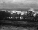
| Date: | 09 06 1964 |
|---|---|
| Description: | View over the CBQ railroad tracks. A tree line grows between the railroad tracks and the Mississippi River, which is visible in the background. |

| Date: | 07 05 1965 |
|---|---|
| Description: | A fishing dock along the shore of the Mississippi River. A man is in a boat near the shoreline, and an automobile is behind a tree. A number of boats are l... |

| Date: | 1969 |
|---|---|
| Description: | This Post Office Department map identifies post offices, summer post offices, rural stations, highway post offices, Post Office sectional centers, rural de... |
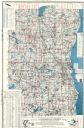
| Date: | 1960 |
|---|---|
| Description: | This map shows lakes arranged by county, depth maps of selected larger lakes, and enlargements of Mississippi River areas. The map also includes locations ... |

| Date: | 1968 |
|---|---|
| Description: | Tourists boarding a paddle steamer along the Mississippi River. |

| Date: | 1967 |
|---|---|
| Description: | Aerial view of what is identified by the caption as a "Nuclear power plant near Victory (Vernon Co.), Wis." This would be the La Crosse Boiling Water React... |
| Date: | 1960 |
|---|---|
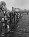
| Description: | View of a crowd of people lined up fishing side by side on long pier. A railroad bridge, with a tanker car, is in the background. |
| Date: | 1961 |
|---|---|
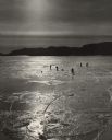
| Description: | People ice fishing on the frozen Mississippi River. Hills can be seen on the shoreline in the background. |

| Date: | 1969 |
|---|---|
| Description: | A map of Wisconsin from The Atlas of the Eight Counties of Forest, Florence, Iron, Langlade, Lincoln, Oneida, Price, Vilas. The map shows rivers and a vari... |
If you didn't find the material you searched for, our Library Reference Staff can help.
Call our reference desk at 608-264-6535 or email us at: