 Filter: Categories of Wisconsin Historical Images
Filter: Subject of Mississippi River
Filter: Year of 1900-1999
Filter: Year of 1950-1959
Filter: Categories of Wisconsin Historical Images
Filter: Subject of Mississippi River
Filter: Year of 1900-1999
Filter: Year of 1950-1959

| Date: | 11 20 1959 |
|---|---|
| Description: | Frazzle ice (snow floating in water) on the Mississippi River near Alma. |

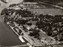
| Date: | 1955 |
|---|---|
| Description: | Aerial view of river and town from a military airplane. |

| Date: | 1955 |
|---|---|
| Description: | Aerial view of La Crosse, with Onalaska in the background. The highway is U.S. Highway 53 and the State Highway 35. |

| Date: | 1953 |
|---|---|
| Description: | Aerial view of La Crosse and the Mississippi River. In the foreground is the new bridge as of 1953. |
| Date: | 1954 |
|---|---|
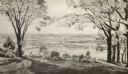
| Description: | View from Brisbois Point. Prairie du Chien lies below, and beyond the Mississippi River rise Iowa's hills. |
| Date: | 1953 |
|---|---|
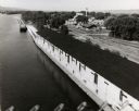
| Description: | View from bridge over the river towards the Diamond Jo warehouse on the shoreline. Hills are in the distance. |
| Date: | 1953 |
|---|---|
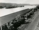
| Description: | Elevated view over the long roof of the Diamond Jo warehouse. The Mississippi River is on the left, and hills are in the background. |
| Date: | 1953 |
|---|---|
| Description: | Elevated view from bridge of the Diamond Jo warehouse along the Mississippi River shoreline. |

| Date: | 1950 |
|---|---|
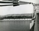
| Description: | Elevated view of the bridge across the Mississippi River between Prairie du Chien, Wisconsin and Marquette, Iowa. Caption reads: "Suspension Bridge Between... |
| Date: | 1958 |
|---|---|
| Description: | Aerial view of town. A bridge over the Mississippi River is in the foreground. |

| Date: | 1957 |
|---|---|
| Description: | Lotus beds on Mississippi River in the foreground and middleground. Bluffs are in the background. |

| Date: | 1950 |
|---|---|
| Description: | This road map shows federal, state and county roads in Wisconsin, northern Illinois, northeastern Iowa, eastern Minnesota, and the western portion of Michi... |

| Date: | 1950 |
|---|---|
| Description: | This map is intended for tourists visiting La Crosse. The front of the map provides extensive text on attractions and activities in La Crosse while the bac... |

| Date: | 1954 |
|---|---|
| Description: | This map of La Crosse shows residential, multiple dwelling, local business, commercial, light industrial, heavy industrial and special multiple dwelling la... |

| Date: | 1956 |
|---|---|
| Description: | This map is intended for tourists of La Crosse. The front of the map is text about attractions, activities, and accommodations in La Crosse. The back is th... |
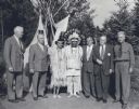
| Date: | 08 1950 |
|---|---|
| Description: | Group portrait of six men and one woman, taken at the headwaters of the Mississippi River, Itasca State Park. C.L. (Neal) Harrington is standing at the far... |

| Date: | 1950 |
|---|---|
| Description: | Intended for tourists, this brochure features two maps with tourists sites along the Mississippi River. One map shows roads and populated places along the ... |

| Date: | 1954 |
|---|---|
| Description: | This map shows the location of Catholic churches, missions, and shrines. The map is color coded and includes a key in the bottom left corner. The back of t... |

| Date: | 01 01 1959 |
|---|---|
| Description: | This map shows many of the rivers, dams, bays, harbors, lakes, and canals. It includes an index of authorized federal project, both for navigation and floo... |
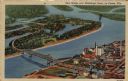
| Date: | 1951 |
|---|---|
| Description: | Aerial view of a highway bridge crossing the Mississippi River and French Island. Caption reads: "New Bridge over Mississippi River, La Crosse, Wis." |
If you didn't find the material you searched for, our Library Reference Staff can help.
Call our reference desk at 608-264-6535 or email us at: