 Filter: Categories of Wisconsin Historical Images
Filter: Subject of Mississippi River
Filter: Year of 1800-1899
Filter: Categories of Wisconsin Historical Images
Filter: Subject of Mississippi River
Filter: Year of 1800-1899

| Date: | 09 1855 |
|---|---|
| Description: | This map shows portions of roads completed, not completed but under contract, and those not yet put under contract. Lakes and rivers are labeled including ... |

| Date: | 1896 |
|---|---|
| Description: | This map shows railroad routes in red, blue, orange, brown, pink, green, and dotted, as well as lakes, rivers, and communities. The map includes a legend i... |
| Date: | 1898 |
|---|---|
| Description: | This map shows railroad routes in red, blue, orange, brown, pink, green, and dotted, as well as lakes, rivers, and communities. The map includes a legend i... |

| Date: | 1895 |
|---|---|
| Description: | View across water towards a house on the banks of the Mississippi River at the base of rocky bluffs. Probably located between Alma and Nelson, along Beef S... |

| Date: | 1851 |
|---|---|
| Description: | This map shows labeled counties in Wisconsin and unlabeled county in Michigan. It includes Door County, which was established 1851, but lacks Kewaunee Coun... |
| Date: | 1850 |
|---|---|
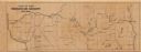
| Description: | This map shows a cross-section of southern Wisconsin, with the Milwaukee and Mississippi Railroad line running from Milwaukee to the Mississippi River near... |
| Date: | 1852 |
|---|---|
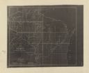
| Description: | This map shows township grid with survey progress, military posts, areas of Indian habitation, cession areas, and treaty lines. Shows the entire state of W... |

| Date: | 1853 |
|---|---|
| Description: | Map of a cross-section of southern Wisconsin, highlighting the La Crosse Milwaukee Rail Road. Shows canals, railroads, plank and post roads, and township g... |

| Date: | 1853 |
|---|---|
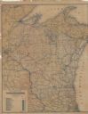
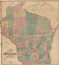
| Description: | This facsimile map shows counties, towns, and waterways in the state of Wisconsin. Included are portions of Iowa, Michigan, and Minnesota. Lake Superior an... |
| Date: | 1879 |
|---|---|
| Description: | This map shows names of triangulation stations, railroads, counties, rivers, and lakes. The Mississippi River, Lake Winnebago, and Lake Michigan are labele... |
| Date: | 1868 |
|---|---|
| Description: | This map shows railroads, counties and towns and includes a township grid. Sections are shown in blue, green, yellow, and pink. Rivers and lakes are labele... |

| Date: | 1868 |
|---|---|
| Description: | This map shows the configurations of the counties, communities, railroads and projected railroads, mines, shipping routes, and labeled rivers and lakes. Po... |

| Date: | 1858 |
|---|---|
| Description: | This map shows the proposed railways of the Tomah & Lake St. Croix Railroad (from Tomah to Hudson) and the St. Croix & Lake Superior Railroad (from Hudson ... |

| Date: | 1829 |
|---|---|
| Description: | This map shows waterways, trails, settlements, Indian villages, and boundaries. The map includes text in the lower left with excerpts from Indian land trea... |
| Date: | 1831 |
|---|---|
| Description: | This map was drawn by a Chippewa leader and shows the boundary lines between the Chippewa and Sioux territories and a saw-mill built by settlers without pe... |

| Date: | 1855 |
|---|---|
| Description: | This map shows current and purposed railroad routes. Lake Michigan is on the far right, with Lake Superior visible at the top of the map. Routes are marked... |

| Date: | 1856 |
|---|---|
| Description: | This map shows the railroad routes and connection of the Mineral Point Railroad. Lake Michigan is on the far right, while Lake Superior is at the top of th... |

| Date: | 1856 |
|---|---|
| Description: | This map shows the railroad routes that lead to Milwaukee. Included are portions of Minnesota, Iowa and Illinois. Lake Michigan is on the right, while Lake... |
| Date: | 1856 |
|---|---|
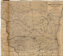
| Description: | This map shows township grids, existing settlements, Indian reservations, rivers, lakes, and treaty lines. Included is a portion of Minnesota. Lake Michiga... |

| Date: | 1857 |
|---|---|
| Description: | This map shows county boundaries, larger cities, lakes, rivers, and the railroad network. The main line is in red, and the Milwaukee and Chicago Railroad i... |
If you didn't find the material you searched for, our Library Reference Staff can help.
Call our reference desk at 608-264-6535 or email us at: