 Filter: Categories of Wisconsin Historical Images
Filter: Subject of Mississippi River
Filter: Subject of transportation
Filter: Categories of Wisconsin Historical Images
Filter: Subject of Mississippi River
Filter: Subject of transportation

| Date: | |
|---|---|
| Description: | Elevated view from bluff of a house in Cassville surrounded by bluffs, trees and farmland. Railroad tracks run between the crops and the trees, and the Mis... |

| Date: | 1895 |
|---|---|
| Description: | View down road with the Bay State House on the left. Three houses and a barbershop also line the street. A lamppost is in the left foreground. The Mississ... |

| Date: | 1925 |
|---|---|
| Description: | Bird's-eye view of Fountain City looking south, with high bluff on the left, and the Mississippi River on the right. Fountain City, about 4 blocks wide, ne... |

| Date: | 1912 |
|---|---|
| Description: | U.S. Army Corps of Engineers (St. Paul District) boatyards. |
| Date: | 1920 |
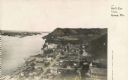
|---|---|
| Description: | Elevated view of Fountain City with the Mississippi River in the background. |
| Date: | 1925 |
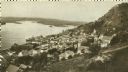
|---|---|
| Description: | Elevated view of Genoa. Caption reads: "Bird's Eye View, Genoa, Wis." The St. Charles Borromeo Catholic Church is in the right foreground. Railroad tracks ... |

| Date: | |
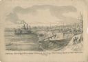
|---|---|
| Description: | "Building rafts, or pontoons, upon which to mount huge mortars — for use on the river. Scene at St. Louis." Men are building on a pontoon with lumber. Ther... |
| Date: | 05 1862 |
|---|---|
| Description: | "Hamburg Landing, 4 miles below Pittsburg Landing, Commisary [sic] Depot of Gen. Hallek's Army." An encampment with soldiers along the river with a ... |

| Date: | 1862 |
|---|---|
| Description: | An image from a sketchbook of "The Gunboats at No. 10 — Eve of Arrival before the I'sld". The drawing appears to be from the deck of a ship showing several... |
| Date: | 1862 |
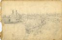
|---|---|
| Description: | This is the preliminary sketch for "Hamburg Landing, 4 miles below Pittsburg Landing, Commisary [sic] Depot of Gen. Hallek's Army." Shows an encampm... |
| Date: | 1866 |
|---|---|
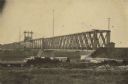
| Description: | Clinton Bridge which crossed the Mississippi River at Clinton, Iowa. |
| Date: | |
|---|---|
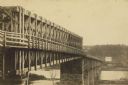
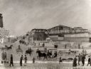
| Description: | A carte-de-visite of an 1790 foot long bridge, 90 feet above the Mississippi River, with the main span at a length of 240 feet in length, at Saint Paul Min... |

| Date: | 1955 |
|---|---|
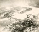
| Description: | Aerial view of river and town from a military airplane. |

| Date: | 1955 |
|---|---|
| Description: | Aerial view of La Crosse, with Onalaska in the background. The highway is U.S. Highway 53 and the State Highway 35. |

| Date: | 1953 |
|---|---|
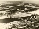
| Description: | Aerial view of La Crosse and the Mississippi River. In the foreground is the new bridge as of 1953. |
| Date: | 1935 |
|---|---|
| Description: | An aerial view of La Crosse and the Mississippi River with the bridge drawn in to show what the finished product would look like. |

| Date: | 1940 |
|---|---|
| Description: | Aerial view of the bridge spanning the Mississippi River in La Crosse. |
| Date: | 09 1939 |
|---|---|
| Description: | View from shoreline towards the bridge over the Mississippi River in La Crosse. |
| Date: | 1891 |
|---|---|
| Description: | A painting of the new (as of 1891) bridge over the Mississippi River in La Crosse. The bridge was built by the Clinton Bridge Co. Captions read: "North sid... |
| Date: | 1940 |
|---|---|
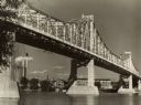
| Description: | The bridge spanning the Mississippi River in La Crosse. |
If you didn't find the material you searched for, our Library Reference Staff can help.
Call our reference desk at 608-264-6535 or email us at: