 Filter: Categories of Wisconsin Historical Images
Filter: Subject of Mississippi River
Filter: Subject of military camps
Filter: Categories of Wisconsin Historical Images
Filter: Subject of Mississippi River
Filter: Subject of military camps
| Date: | 05 1862 |
|---|---|
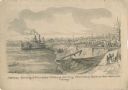
| Description: | "Hamburg Landing, 4 miles below Pittsburg Landing, Commisary [sic] Depot of Gen. Hallek's Army." An encampment with soldiers along the river with a ... |

| Date: | 1912 |
|---|---|
| Description: | This map from the U.S. General Land Office shows railroads, counties, cities and villages, rivers, lakes, U.S. Land Offices, Indian reservations, military ... |

| Date: | |
|---|---|
| Description: | A hand-drawn map of Camp Curtis which was prepared for Colonel R. McMurphy. |
If you didn't find the material you searched for, our Library Reference Staff can help.
Call our reference desk at 608-264-6535 or email us at: