 Filter: Categories of Wisconsin Historical Images
Filter: Subject of Mississippi River
Filter: Subject of land
Filter: Categories of Wisconsin Historical Images
Filter: Subject of Mississippi River
Filter: Subject of land

| Date: | 1814 |
|---|---|
| Description: | Map of the Upper Territories of the United States. |
| Date: | 04 1862 |
|---|---|
| Description: | Notes include: Sketch of Battle of Island #10. Sketch of Fort Pillow Tennessee. Gen. Pope had command of the land troops. |

| Date: | 1862 |
|---|---|
| Description: | An image from a sketchbook of "The Gunboats at No. 10 — Eve of Arrival before the I'sld". The drawing appears to be from the deck of a ship showing several... |
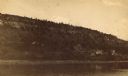
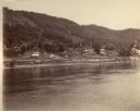
| Date: | 1887 |
|---|---|
| Description: | View over Mississippi River of town on shoreline with bluff in the background. |

| Date: | 1945 |
|---|---|
| Description: | Wyalusing State Park in the Prairie du Chein vicinity. The Wisconsin River is in the foreground and the Mississippi river can be seen below with distant bl... |

| Date: | 1955 |
|---|---|
| Description: | Aerial view of La Crosse, with Onalaska in the background. The highway is U.S. Highway 53 and the State Highway 35. |

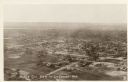
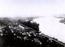
| Date: | 1953 |
|---|---|
| Description: | Aerial view of La Crosse and the Mississippi River. In the foreground is the new bridge as of 1953. |
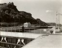
| Date: | 1935 |
|---|---|
| Description: | Locks on the Mississippi River, a nine foot channel. A man is standing above the locks. Bluffs are in the background. |
| Date: | |
|---|---|
| Description: | Aerial view of La Crosse, with the Mississippi River in the distance. |

| Date: | 1900 |
|---|---|
| Description: | Elevated view of La Crosse. Caption reads: "Panorama of La Crosse, Wis. from Grand Dad's Bluff." |

| Date: | 09 1962 |
|---|---|
| Description: | The Mississippi River along Highway 35. |
| Date: | |
|---|---|
| Description: | View across the river towards buildings along the shoreline in Victory. |

| Date: | 1804 |
|---|---|
| Description: | A map of Lewis and Clark's Track across the western portion of North America from the Mississippi River to the Pacific Ocean by order of the Executive of t... |
| Date: | 1907 |
|---|---|
| Description: | Elevated view from first peak of Trempealeau, Wisconsin. |

| Date: | 1910 |
|---|---|
| Description: | Colorized view of the Maiden's Rock, as viewed from Lake City, Minnesota. This was the legendary lover's leap of Wenonah, the first-born daughter of Dakota... |

| Date: | 1905 |
|---|---|
| Description: | The view of the Lake Front from across the Mississippi River. Caption reads: "Lake Front at Maiden Rock, Wis." |

| Date: | 1829 |
|---|---|
| Description: | Cincinnati, Ohio, Ebr. Martin, engraver. |

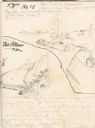
| Date: | 1820 |
|---|---|
| Description: | A manuscript map of Prairie du Chien. |

| Date: | 1835 |
|---|---|
| Description: | Constructed for the Topographical Bureau [Wash.], 1835. Scale: 16 miles to 1 inch. Map of a portion of the Indian country lying east and west of the Missis... |

| Date: | 1870 |
|---|---|
| Description: | Half stereograph of an elevated view from hill showing the confluence of the Mississippi River and the St. Croix River. A man wearing a hat is in the foreg... |
If you didn't find the material you searched for, our Library Reference Staff can help.
Call our reference desk at 608-264-6535 or email us at: