 Filter: Categories of Wisconsin Historical Images
Filter: Subject of Mississippi River
Filter: Subject of land
Filter: Categories of Wisconsin Historical Images
Filter: Subject of Mississippi River
Filter: Subject of land

| Date: | 1882 |
|---|---|
| Description: | A hand-colored, sectional map of Wisconsin showing the township grid, completed and proposed railroads, counties, towns, cities, villages. The map also inc... |
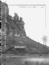
| Date: | 1905 |
|---|---|
| Description: | Large rock formation with farm outbuildings, and what appears to be railroad tracks at the base. The Mississippi River is in the foreground. Crop on image ... |

| Date: | 1910 |
|---|---|
| Description: | Man sitting in a speed boat named "Badger" on the Mississippi River. There are flags at the stern and bow. In the background is the town of Cassville along... |

| Date: | 1915 |
|---|---|
| Description: | View from shoreline of ferry carrying three automobiles on the Mississippi River. An excursion boat is in the water nearby, and buildings are on the far sh... |
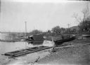
| Date: | 1910 |
|---|---|
| Description: | A view along the Mississippi River shoreline after a storm. The water is high and there are damaged boats and debris scattered around. In the background me... |
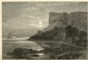
| Date: | 1874 |
|---|---|
| Description: | Engraved view of Maiden's Rock at Lake Pepin. A steamboat is on the Mississippi River. |

| Date: | 1908 |
|---|---|
| Description: | A Frank Feiker "Souvenir' postcard depicting a Chicago, Milwaukee, St. Paul and Pacific railroad bridge. A man is standing at the front of the bridge. |

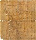
| Date: | 1873 |
|---|---|
| Description: | A map that covers parts of Winona and Houston Counties, Minnesota and La Crosse County, Wisconsin, showing the proposed railroad routes, constructed rail l... |

| Date: | |
|---|---|
| Description: | A map of La Crosse, Wisconsin and La Crescent, Minnesota, showing sectional divisions along the shore and islands of the Mississippi River. The areas also ... |

| Date: | 1920 |
|---|---|
| Description: | An ink on tracing paper, hand-drawn map that shows lead mines, the boundary of the lead bearing strata, and the military road in Lafayette, Grant, Iowa, an... |

| Date: | 1900 |
|---|---|
| Description: | Elevated view over city. A church is in the middle foreground, and the Mississippi River and far shoreline is in the background. On the right side is a dir... |

| Date: | 1904 |
|---|---|
| Description: | Panoramic view of Governor Nelson Dewey's estate. The left image is of an old stone barn with a shed in the rear. The center image is another barn. The rig... |

| Date: | 1905 |
|---|---|
| Description: | View from water of a small cabin near the shore of the Mississippi River. |

| Date: | |
|---|---|
| Description: | View down Denniston Avenue. On the left side behind a long row of fences along the sidewalk are dwellings and a church. On the right side dwellings are alo... |

| Date: | 1920 |
|---|---|
| Description: | A map of the Nelson-Dewey State Park at the confluence of the Mississippi and Wisconsin rivers, showing the topographical features of the area, as well as ... |

| Date: | 1920 |
|---|---|
| Description: | This 1920 map actually depicts present-day Wyalusing State Park at the confluence of the Mississippi and Wisconsin rivers in the Town of Wyalusing, Grant C... |

| Date: | 1922 |
|---|---|
| Description: | This map of Pierce County, Wisconsin, from the first half of the 20th century, shows the township and range grid, towns, sections, villages, roads, railroa... |

| Date: | |
|---|---|
| Description: | This 19th century manuscript map shows the township and range systems, sections, and acreages along the Mississippi River in the towns of Freeman and Senec... |
| Date: | |
|---|---|
| Description: | This 19th century manuscript map shows state lands and acreages along the Mississippi River and the sections in parts of what is currently the Town of Shel... |
If you didn't find the material you searched for, our Library Reference Staff can help.
Call our reference desk at 608-264-6535 or email us at:
