Filter: Categories of Wisconsin Historical Images
Filter: Subject of Mississippi River
Filter: Subject of land
Filter: Year of 1900-1999
Filter: Year of 1920-1929
Filter: Categories of Wisconsin Historical Images
Filter: Subject of Mississippi River
Filter: Subject of land
Filter: Year of 1900-1999
Filter: Year of 1920-1929

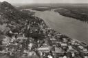
| Date: | 1925 |
|---|---|
| Description: | Caption reads: "Bird's Eye View of Fountain City, Wis. M-1255". Aerial view of town with the river on the right. |

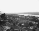
| Date: | 1925 |
|---|---|
| Description: | Bird's-eye view of Fountain City looking south, with high bluff on the left, and the Mississippi River on the right. Fountain City, about 4 blocks wide, ne... |

| Date: | 1925 |
|---|---|
| Description: | View of Eagle Bluff, the highest point on the Mississippi River. |
| Date: | 1920 |
|---|---|
| Description: | Elevated view of Fountain City with the Mississippi River in the background. |
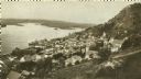
| Date: | 1925 |
|---|---|
| Description: | Elevated view of Genoa. Caption reads: "Bird's Eye View, Genoa, Wis." The St. Charles Borromeo Catholic Church is in the right foreground. Railroad tracks ... |

| Date: | 1923 |
|---|---|
| Description: | Photographic postcard of scenes from Alma. Three scenes from areas around Alma show the town along the Mississippi River, an elevated view of the river bet... |
| Date: | 1921 |
|---|---|
| Description: | View from bluff of Cassville with the Mississippi River in the background. |
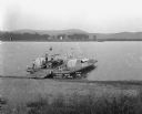
| Date: | 1921 |
|---|---|
| Description: | View from shoreline looking down at three men posing on a paddle steamer ferry boat carrying an automobile. The boat has the words "Cassville" and "Dewey" ... |

| Date: | 1928 |
|---|---|
| Description: | This map shows geological formations throughout Wisconsin. Lakes and rivers are labeled, including The Mississippi River, Lake Superior, and Lake Michigan.... |
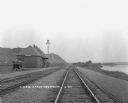
| Date: | 1925 |
|---|---|
| Description: | View down double set of railroad tracks with the De Soto depot on the left and the Mississippi River on the right. A car is parked at the depot, and bluffs... |

| Date: | 1920 |
|---|---|
| Description: | Shows 10 land and water trails along rivers and other bodies of water in northern Wisconsin and the Upper Peninsula of Michigan; each trail numbered and de... |

| Date: | 1928 |
|---|---|
| Description: | Map of portions of Wisconsin and Minnesota between Lake Superior and Mississippi River, showing railroads and military road. |

| Date: | 1929 |
|---|---|
| Description: | View down high bridge of two passenger cars passing one another while crossing over the Mississippi River. |
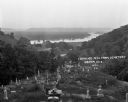
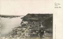
| Date: | 1922 |
|---|---|
| Description: | View from the hilltop at the Genoa cemetery looking down towards the village, the Mississippi River and the Minnesota border. |

| Date: | 1925 |
|---|---|
| Description: | A metal bridge from La Crescent over the Mississippi River to La Crosse. |

| Date: | 1920 |
|---|---|
| Description: | An ink on tracing paper, hand-drawn map that shows lead mines, the boundary of the lead bearing strata, and the military road in Lafayette, Grant, Iowa, an... |

| Date: | 1920 |
|---|---|
| Description: | A map of the Nelson-Dewey State Park at the confluence of the Mississippi and Wisconsin rivers, showing the topographical features of the area, as well as ... |

| Date: | 1920 |
|---|---|
| Description: | This 1920 map actually depicts present-day Wyalusing State Park at the confluence of the Mississippi and Wisconsin rivers in the Town of Wyalusing, Grant C... |

| Date: | 1922 |
|---|---|
| Description: | This map of Pierce County, Wisconsin, from the first half of the 20th century, shows the township and range grid, towns, sections, villages, roads, railroa... |
If you didn't find the material you searched for, our Library Reference Staff can help.
Call our reference desk at 608-264-6535 or email us at: