 Filter: Categories of Wisconsin Historical Images
Filter: Subject of Mississippi River
Filter: Subject of land
Filter: Year of 1800-1899
Filter: Categories of Wisconsin Historical Images
Filter: Subject of Mississippi River
Filter: Subject of land
Filter: Year of 1800-1899
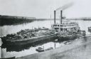
| Date: | 1875 |
|---|---|
| Description: | View down hill towards "Diamond Jo" steamboat docked on the shoreline of the Mississippi River while goods are being loaded onto the steamboat. |
| Date: | 1893 |
|---|---|
| Description: | Six men of the fishing colony on the shorelines of the Mississippi River. Numerous boats, logs, and fishing nets are scattered across the beach. Caption on... |

| Date: | 1829 |
|---|---|
| Description: | Hand-colored lithograph of Fort Armstrong on Rock Island, based on a drawing by Henry Lewis. Foreground shows a tree floating in the water. |

| Date: | 1829 |
|---|---|
| Description: | Hand-colored lithograph of Fort Armstrong, based on a drawing by Henry Lewis. Includes boats on the Mississippi River. |

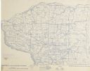
| Date: | 1828 |
|---|---|
| Description: | Plat of the Private Claims at Prairie Du Chien. |

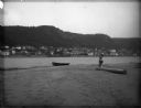
| Date: | 1890 |
|---|---|
| Description: | A view from a hill overlooking the town of Alma, on the banks of the Mississippi River, which is frozen. Several churches and residential houses are visibl... |
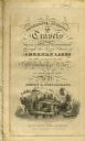
| Date: | 1820 |
|---|---|
| Description: | Narrative Journal of Travels from Detroit Northwest through the Great chain of American Lakes to the sources of the Mississippi River in the year 1820. Ill... |
| Date: | 1896 |
|---|---|
| Description: | Section 4 of 12, this bicycle road map features Wisconsin bicycle routes in the counties of Iowa, Grant, and La Fayette. |

| Date: | 1896 |
|---|---|
| Description: | Section 5 of 12, this bicycle road map features Wisconsin bicycle routes in the counties of La Crosse, Monroe, Vernon, Crawford, Richland, Sauk, Juneau, an... |

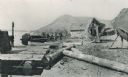
| Date: | 1887 |
|---|---|
| Description: | Men on shoreline are returning logs with horses, which have been stranded on a sandbar, to the main channel of the Mississippi River. Beef Slough Company w... |
| Date: | 1890 |
|---|---|
| Description: | View of Alma across river from sandbar. A rowboat is on the sandbar, and on the right a father and child are standing posed each with one foot on a log. |

| Date: | 1885 |
|---|---|
| Description: | Four men and one woman in a rowboat on the Mississippi River. In the background is the town of Alma at the foot of bluffs. The woman is holding an umbrella... |

| Date: | 1895 |
|---|---|
| Description: | Christmas postcard of four men and one woman in a rowboat on the Mississippi River. In the background is the town of Alma at the foot of bluffs. The woman ... |
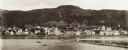
| Date: | 1897 |
|---|---|
| Description: | View of Alma from the Mississippi River, with wing dam on right. |

| Date: | 1878 |
|---|---|
| Description: | Illustrated map of Crawford County. On the bottom right is an inset of a group of people near a train on a railroad track. |

| Date: | 1842 |
|---|---|
| Description: | A map of the Western rivers, a "travellers guide" exhibiting the Mississippi, Missouri, Ohio and Illinois Rivers with principal towns. |

| Date: | 1862 |
|---|---|
| Description: | This map lists and depicts the positions of "the batteries on Kentucky shore" and the "batteries on Island No. 10." The 8th Wisconsin Infantry and 15th Wis... |

| Date: | 1860 |
|---|---|
| Description: | This colored map shows railroad lines east of the Mississippi as well as in the states bordering the Mississippi River. The Great Lakes and Gulf of Mexico ... |

| Date: | 1844 |
|---|---|
| Description: | A hand-colored map and chart showing a geological cross-section from Rockingham, in present-day Scott County, Iowa, through Blue Mounds to the Wisconsin Ri... |

| Date: | 1835 |
|---|---|
| Description: | Ink on tracing paper map of Green Bay, Wisconsin and nearby areas, Lake Winnebago, Fox and Wolf Rivers, and the junctions of the Mississippi and Wisconsin ... |
If you didn't find the material you searched for, our Library Reference Staff can help.
Call our reference desk at 608-264-6535 or email us at: