 Filter: Categories of Wisconsin Historical Images
Filter: Subject of Mississippi River
Filter: Subject of land
Filter: Year of 1800-1899
Filter: Categories of Wisconsin Historical Images
Filter: Subject of Mississippi River
Filter: Subject of land
Filter: Year of 1800-1899

| Date: | 1899 |
|---|---|
| Description: | This map is a folded insert from the pamphlet "Yesterday and Today : A History." The map features the North-Western Line with labeled railway tracks and st... |

| Date: | 1890 |
|---|---|
| Description: | This map features township outlines, railroads, roads, post offices, and landownership for La Crosse County. Various communities appear in yellow, green, a... |

| Date: | 1882 |
|---|---|
| Description: | This map is ink on cardboard and shows the location of military forts over the course of years. Also shown are points of interest, streets, the Mississippi... |

| Date: | 1800 |
|---|---|
| Description: | This map is ink and watercolor on paper and shows the main channel and sand bars in the Mississippi River between villages. |

| Date: | 1838 |
|---|---|
| Description: | This map is a development plat that shows street names, numbered blocks and lots, and small farm lot owners. Included on the right of the map is a large am... |

| Date: | 06 1853 |
|---|---|
| Description: | This map is ink, pencil, and color on paper and shows lot and block numbers and dimensions, sold lots, streets, and the Mississippi River. Some lots are co... |

| Date: | 1856 |
|---|---|
| Description: | This map shows lot and block numbers, streets, the Mississippi River, Fort Crawford, depot ground, and a graveyard. An old fort location is outlined in red... |

| Date: | 12 05 1854 |
|---|---|
| Description: | This plat map shows landowners, the Mississippi River, the Marais de St. Friole, and an old fort. The left margin reads: "Part of the Main Village of Prair... |

| Date: | 1828 |
|---|---|
| Description: | This plat map is pen-and-ink and shows landowners, the Mississippi River, the Marais de St. Friole, Fort Crawford, the town commons, and the Village of St.... |

| Date: | 1828 |
|---|---|
| Description: | This map is pen-and-ink and served as the model for the lithograph produced in 1828 by C.B. Graham. Landowners are labeled as is the Mississippi River. |

| Date: | 1839 |
|---|---|
| Description: | This map, one of a series made by Thomas Jefferson Cram of the U.S. Topographical Engineers from personal surveys, covers the area from Green Bay to the ju... |

| Date: | 1846 |
|---|---|
| Description: | This map shows rivers, lakes, and towns in states west of the Mississippi River. Lake Michigan, Lake Superior, and Green Bay are labeled. Some areas are ou... |

| Date: | 1837 |
|---|---|
| Description: | This map shows the planned military posts/depots, roads, existing forts, rivers, and land assigned to various Indian tribes. Illinois, Mississippi, Arkansa... |

| Date: | 1895 |
|---|---|
| Description: | View across water towards a house on the banks of the Mississippi River at the base of rocky bluffs. Probably located between Alma and Nelson, along Beef S... |
| Date: | 1879 |
|---|---|
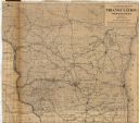
| Description: | This map shows names of triangulation stations, railroads, counties, rivers, and lakes. The Mississippi River, Lake Winnebago, and Lake Michigan are labele... |
| Date: | 1868 |
|---|---|
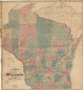
| Description: | This map shows railroads, counties and towns and includes a township grid. Sections are shown in blue, green, yellow, and pink. Rivers and lakes are labele... |

| Date: | 1868 |
|---|---|
| Description: | This map shows the configurations of the counties, communities, railroads and projected railroads, mines, shipping routes, and labeled rivers and lakes. Po... |

| Date: | 1839 |
|---|---|
| Description: | This map shows the geological makeup of the valley in red, yellow, and green, the Mississippi River, and the location of Fort Crawford. The geology on the ... |

| Date: | 1800 |
|---|---|
| Description: | Map of the new state of Tennessee. It shows borders, numerous boundary lines (particularly Native American boundaries), towns (European and Native American... |
| Date: | 04 18 1888 |
|---|---|
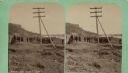
| Description: | Stereograph of fireplace ruins on the site of an old French fort, possibly built by Nicholas Perrot. There is an electric pole behind the fireplace and a g... |
If you didn't find the material you searched for, our Library Reference Staff can help.
Call our reference desk at 608-264-6535 or email us at: