 Filter: Categories of Wisconsin Historical Images
Filter: Subject of Mississippi River
Filter: Subject of land
Filter: Subject of signs and symbols
Filter: Categories of Wisconsin Historical Images
Filter: Subject of Mississippi River
Filter: Subject of land
Filter: Subject of signs and symbols

| Date: | 1868 |
|---|---|
| Description: | The sidewheel packet, Keokuk, loaded with passengers beside a barge at a landing. The landing is filled with people and horse-drawn vehicles. The si... |

| Date: | 1885 |
|---|---|
| Description: | Mississippi River stereograph, with a St. Jacob's Oil building in the distance. |
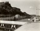
| Date: | 1935 |
|---|---|
| Description: | Locks on the Mississippi River, a nine foot channel. A man is standing above the locks. Bluffs are in the background. |

| Date: | |
|---|---|
| Description: | Map reads: "Historic and Scenic Wisconsin — Land of Gathering Waters." In an inset there is a hand-painted depiction of the Wisconsin State Seal. For some ... |
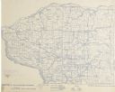
| Date: | 1896 |
|---|---|
| Description: | Section 4 of 12, this bicycle road map features Wisconsin bicycle routes in the counties of Iowa, Grant, and La Fayette. |

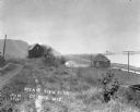
| Date: | |
|---|---|
| Description: | View across water towards two paddle-wheel boats steering logs into a neat, square formation. The boat in the foreground bears the name "Georgie S." Bluffs... |

| Date: | |
|---|---|
| Description: | Map of Baraboo and its surroundings, showing the ancient mound city, the water power, and thoroughfares, drawn by William H. Canfield. Canfield includes sk... |
| Date: | 1914 |
|---|---|
| Description: | View down path along rough road towards a building labeled "No. 4". The De Soto Depot, railroad tracks, a boxcar, and the Mississippi River are below on th... |
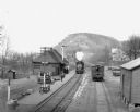
| Date: | 1912 |
|---|---|
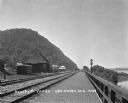
| Description: | Elevated view of the De Soto depot. A locomotive, blowing steam, is approaching the platform, where a small group of people waits to board. A boxcar on the... |
| Date: | 1925 |
|---|---|
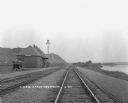
| Description: | View down double set of railroad tracks with the De Soto depot on the left and the Mississippi River on the right. A car is parked at the depot, and bluffs... |
| Date: | 1909 |
|---|---|
| Description: | View along a brick platform towards the Glen Haven depot, where two men stand against the building. Behind the depot is a building with a sign for the "Me... |

| Date: | 1910 |
|---|---|
| Description: | Man sitting in a speed boat named "Badger" on the Mississippi River. There are flags at the stern and bow. In the background is the town of Cassville along... |

| Date: | 1875 |
|---|---|
| Description: | This map, from G.K. Warren's 1876 Report on the transportation route along the Wisconsin and Fox rivers in the State of Wisconsin between the Mississippi R... |

| Date: | 1929 |
|---|---|
| Description: | Elevated view from Signal Point of the Mississippi River, railroad and surrounding forest and wetlands. |

| Date: | 1859 |
|---|---|
| Description: | This map show plats including plat names, plat numbers, and some lot owner's names. Relief is shown by hachures. The map includes line drawings of Juneau B... |
| Date: | 1906 |
|---|---|
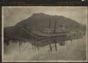
| Description: | View across water towards the steamer Quincy, of the Diamond Jo Line, partially sunken into the Mississippi River and listing to port near the shore... |
| Date: | 1935 |
|---|---|
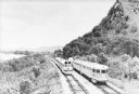
| Description: | Two streamlined style, stainless steel clad passenger trains meet on the tracks at the base of a bluff along the Mississippi River near La Crosse. A sign ... |

| Date: | |
|---|---|
| Description: | View across Mississippi River towards the La Crosse waterfront. Postcard is folded in four parts, and text on front reads: "Mail Card. Write on back of thi... |

| Date: | 05 08 1927 |
|---|---|
| Description: | Two men are standing by a sign, near a fence, marking the former location of Fort Antoine. |

| Date: | 1950 |
|---|---|
| Description: | View of an automobile traveling north on Highway 35, near the Mississippi River. Railroad tracks run between the road and the river. In the background are ... |
If you didn't find the material you searched for, our Library Reference Staff can help.
Call our reference desk at 608-264-6535 or email us at: