 Filter: Categories of Wisconsin Historical Images
Filter: Subject of Mississippi River
Filter: Subject of land
Filter: County of Grant
Filter: Year of 1900-1999
Filter: Categories of Wisconsin Historical Images
Filter: Subject of Mississippi River
Filter: Subject of land
Filter: County of Grant
Filter: Year of 1900-1999

| Date: | 1900 |
|---|---|
| Description: | Elevated view of the brewery dwarfed by the overhead bluffs. The brewery was built by William Schmitz. George Scheibl ran the brewery from 1899 until his d... |
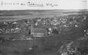
| Date: | 1900 |
|---|---|
| Description: | View from bluff looking northwest at the town of Cassville. A church in the center is the dominant structure in the foreground. Caption reads: "Souvenir - ... |
| Date: | 1900 |
|---|---|
| Description: | Aerial view of town. The Mississippi River and far shoreline is in the background. The Furnace Branch creek runs through the town in the foreground. |

| Date: | 1945 |
|---|---|
| Description: | Wyalusing State Park in the Prairie du Chein vicinity. The Wisconsin River is in the foreground and the Mississippi river can be seen below with distant bl... |
| Date: | 1938 |
|---|---|
| Description: | View from road leading down to shoreline of a Mississippi River ferry bringing several cars across the river. |
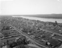
| Date: | 1921 |
|---|---|
| Description: | View from bluff of Cassville with the Mississippi River in the background. |
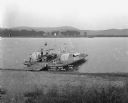
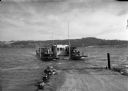
| Date: | 1921 |
|---|---|
| Description: | View from shoreline looking down at three men posing on a paddle steamer ferry boat carrying an automobile. The boat has the words "Cassville" and "Dewey" ... |

| Date: | 1929 |
|---|---|
| Description: | View down high bridge of two passenger cars passing one another while crossing over the Mississippi River. |
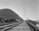
| Date: | 1909 |
|---|---|
| Description: | View along a brick platform towards the Glen Haven depot, where two men stand against the building. Behind the depot is a building with a sign for the "Me... |
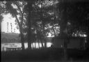
| Date: | 1910 |
|---|---|
| Description: | A small cottage in a wooded setting. There is a small boat with a man on the shoreline. There is a steep bluff on the far shoreline. A Frank Feiker 'Souven... |
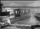
| Date: | 1910 |
|---|---|
| Description: | The cruiser is tied-up on the beach shore. |

| Date: | 1910 |
|---|---|
| Description: | Man sitting in a speed boat named "Badger" on the Mississippi River. There are flags at the stern and bow. In the background is the town of Cassville along... |

| Date: | 1915 |
|---|---|
| Description: | View from shoreline of ferry carrying three automobiles on the Mississippi River. An excursion boat is in the water nearby, and buildings are on the far sh... |
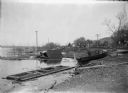
| Date: | 1910 |
|---|---|
| Description: | A view along the Mississippi River shoreline after a storm. The water is high and there are damaged boats and debris scattered around. In the background me... |

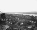
| Date: | 1900 |
|---|---|
| Description: | Elevated view over city. A church is in the middle foreground, and the Mississippi River and far shoreline is in the background. On the right side is a dir... |

| Date: | 1904 |
|---|---|
| Description: | Panoramic view of Governor Nelson Dewey's estate. The left image is of an old stone barn with a shed in the rear. The center image is another barn. The rig... |

| Date: | 1905 |
|---|---|
| Description: | View from water of a small cabin near the shore of the Mississippi River. |

| Date: | 1920 |
|---|---|
| Description: | A map of the Nelson-Dewey State Park at the confluence of the Mississippi and Wisconsin rivers, showing the topographical features of the area, as well as ... |

| Date: | 1920 |
|---|---|
| Description: | This 1920 map actually depicts present-day Wyalusing State Park at the confluence of the Mississippi and Wisconsin rivers in the Town of Wyalusing, Grant C... |

| Date: | 1972 |
|---|---|
| Description: | Ink on tracing paper. This map shows rivers, Prairie du Chien, site of Fort Crawford, Excelsior, Fort Andrew, Boscobel, Blue River, Orion, Muscoda, Castle ... |
If you didn't find the material you searched for, our Library Reference Staff can help.
Call our reference desk at 608-264-6535 or email us at: