 Filter: Categories of Wisconsin Historical Images
Filter: Subject of Mississippi River
Filter: Subject of land
Filter: Community of La Crosse
Filter: Year of 1900-1999
Filter: Categories of Wisconsin Historical Images
Filter: Subject of Mississippi River
Filter: Subject of land
Filter: Community of La Crosse
Filter: Year of 1900-1999

| Date: | 1955 |
|---|---|
| Description: | Aerial view of La Crosse, with Onalaska in the background. The highway is U.S. Highway 53 and the State Highway 35. |

| Date: | 1953 |
|---|---|
| Description: | Aerial view of La Crosse and the Mississippi River. In the foreground is the new bridge as of 1953. |
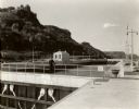
| Date: | 1935 |
|---|---|
| Description: | Locks on the Mississippi River, a nine foot channel. A man is standing above the locks. Bluffs are in the background. |

| Date: | 1900 |
|---|---|
| Description: | Elevated view of La Crosse. Caption reads: "Panorama of La Crosse, Wis. from Grand Dad's Bluff." |
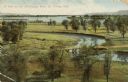
| Date: | 1909 |
|---|---|
| Description: | Elevated view of winding tributaries leading to Mississippi River. A road passes over a bridge in the foreground. Caption reads: "A View on the Mississippi... |

| Date: | 1940 |
|---|---|
| Description: | This map of La Crosse shows different types of land zoning: residence, multiple dwelling, local business, commercial, light industrial, heavy industrial, w... |

| Date: | 1950 |
|---|---|
| Description: | This map is intended for tourists visiting La Crosse. The front of the map provides extensive text on attractions and activities in La Crosse while the bac... |

| Date: | 1956 |
|---|---|
| Description: | This map is intended for tourists of La Crosse. The front of the map is text about attractions, activities, and accommodations in La Crosse. The back is th... |

| Date: | 1972 |
|---|---|
| Description: | This map of La Crosse is a plan for the city parks and recreation areas. The cover features an explanation of the Park and Recreation plan, objectives of t... |

| Date: | 1900 |
|---|---|
| Description: | The map is watercolor, pencil, and ink on tracing cloth and shows plats of both cities, local streets, railroads, mills, township divisions, bridges, and p... |

| Date: | 04 09 1936 |
|---|---|
| Description: | The Buffalo Head, a 'native' stone sculpture by the Mississippi River at the junction of Flint Ledge and Indian trails in Wyalusing State Park. The verso... |

| Date: | 1900 |
|---|---|
| Description: | This set of photocopy bird's-eye-view maps include one view looking west from the top of Wisconsin River bluffs; and a second view looking east towards La ... |
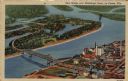
| Date: | 1951 |
|---|---|
| Description: | Aerial view of a highway bridge crossing the Mississippi River and French Island. Caption reads: "New Bridge over Mississippi River, La Crosse, Wis." |

| Date: | 1907 |
|---|---|
| Description: | View towards a hill, on the far left in the distance, with a geologic formation at the top. A road is winding through the hillside. The Mississippi River i... |

| Date: | 1950 |
|---|---|
| Description: | View of a driveway and sidewalk along the Mississippi River. An interstate bridge and bluffs are in the distance. Caption reads: "Driveway, Pettibone Park,... |
If you didn't find the material you searched for, our Library Reference Staff can help.
Call our reference desk at 608-264-6535 or email us at: