 Filter: Categories of Wisconsin Historical Images
Filter: Subject of Mississippi River
Filter: Subject of land
Filter: Community of Cassville
Filter: Categories of Wisconsin Historical Images
Filter: Subject of Mississippi River
Filter: Subject of land
Filter: Community of Cassville

| Date: | |
|---|---|
| Description: | Elevated view of Cassville, including the town hall and St. Peter's Church. |

| Date: | 12 07 1907 |
|---|---|
| Description: | Elevated photographic postcard view of a paddle steamer towing rafts loaded with logs through an open pontoon bridge on the Mississippi River. Caption read... |
| Date: | |
|---|---|
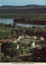
| Description: | Elevated view of Stonefield Village, with the Mississippi River in the background. Caption reads: "Stonefield, Cassville, Wis." |

| Date: | 1850 |
|---|---|
| Description: | This map of Cassville shows plat of town, roads, and the Mississippi River. Relief is shown by hachures. The map includes an inset map of a Plat of townshi... |

| Date: | 1850 |
|---|---|
| Description: | This map of Cassville shows plat of the town, roads, landings and public wharfs and the Mississippi River. |
| Date: | 1935 |
|---|---|
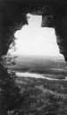
| Description: | A retouched, elevated view, looking out the mouth of a cave, over Nelson Dewey State Park. Far below are a railroad bridge and the backwaters of the Missis... |
If you didn't find the material you searched for, our Library Reference Staff can help.
Call our reference desk at 608-264-6535 or email us at: