 Filter: Categories of Wisconsin Historical Images
Filter: Subject of Mississippi River
Filter: Subject of land
Filter: Creator Name of Unknown
Filter: Categories of Wisconsin Historical Images
Filter: Subject of Mississippi River
Filter: Subject of land
Filter: Creator Name of Unknown

| Date: | |
|---|---|
| Description: | View across water towards two paddle-wheel boats steering logs into a neat, square formation. The boat in the foreground bears the name "Georgie S." Bluffs... |

| Date: | |
|---|---|
| Description: | View along shoreline toward five young boys posing in a rowboat near a large piece of driftwood. Another boat is docked at a pier further down the shorelin... |

| Date: | |
|---|---|
| Description: | View down steep hill at the shoreline looking toward two young boys sitting in a rowboat below. A group of people in a boat are in the distance along the o... |

| Date: | |
|---|---|
| Description: | View toward a river and surrounding landscape, taken from a high vantage point. In the foreground are a series of wooden structures. Trees line the river a... |

| Date: | |
|---|---|
| Description: | View across water toward a railroad bridge, constructed of heavy steel that sits on massive stone supports. Wooded hills are in the background. |

| Date: | 1842 |
|---|---|
| Description: | A map of the Western rivers, a "travellers guide" exhibiting the Mississippi, Missouri, Ohio and Illinois Rivers with principal towns. |

| Date: | 01 02 1915 |
|---|---|
| Description: | Photographic postcard from the Mississippi of the city of Alma. The city of Alma is along Wisconsin State Highway 35, also known as the Great River Road. T... |

| Date: | 12 29 1914 |
|---|---|
| Description: | Photographic postcard view of Alma looking north. The Mississippi River is in the foreground. Caption reads: "Alma, Wis." |

| Date: | 12 1914 |
|---|---|
| Description: | Photographic postcard view of southern Alma with buildings and bluffs. The Mississippi River and the shoreline are in the foreground. Caption reads: "Alma,... |

| Date: | 08 03 1913 |
|---|---|
| Description: | Colorized postcard of the Mississippi River and bluffs near Alma. A docked paddle boat is near the shoreline. Caption reads: "A Scene from the River, Alma,... |

| Date: | 04 12 1907 |
|---|---|
| Description: | Photographic postcard of an aerial view of town looking North. The Mississippi River is on the left. |

| Date: | 1928 |
|---|---|
| Description: | Map of portions of Wisconsin and Minnesota between Lake Superior and Mississippi River, showing railroads and military road. |

| Date: | 1900 |
|---|---|
| Description: | A map of Wisconsin, eastern Minnesota and Iowa, northern Iowa, and Michigan’s Upper Peninsula, showing railway lines, with those marked with heavy red line... |

| Date: | 1835 |
|---|---|
| Description: | Plat for a proposed Sinsinawa City (never built), in Grant County, Wis. When it became clear in the mid-1830s that Wisconsin Territory would be established... |

| Date: | 02 1823 |
|---|---|
| Description: | A map featuring the North American expedition from Pittsburgh to the Rocky Mountains led by Edwin James. |
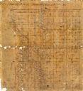
| Date: | |
|---|---|
| Description: | This 19th century manuscript map shows state lands and acreages along the Mississippi River and the sections in parts of what is currently the Town of Shel... |

| Date: | |
|---|---|
| Description: | This 19th century manuscript map shows land claims near the confluence of the Wisconsin River with the Mississippi River in the Town of Bridgeport, Crawfor... |

| Date: | 1887 |
|---|---|
| Description: | Map of the Fox and Wisconsin Rivers to accompany Reuben Gold Thwaites' Historic Waterways. |

| Date: | 1918 |
|---|---|
| Description: | View from shoreline of three men standing in the water at Mechanic's Rock on the Mississippi River. |
If you didn't find the material you searched for, our Library Reference Staff can help.
Call our reference desk at 608-264-6535 or email us at:
