Filter: Categories of Wisconsin Historical Images
Filter: Subject of Mississippi River
Filter: Subject of human settlements
Filter: Categories of Wisconsin Historical Images
Filter: Subject of Mississippi River
Filter: Subject of human settlements

| Date: | 09 1962 |
|---|---|
| Description: | The Mississippi River along Highway 35. |
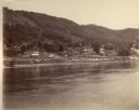
| Date: | |
|---|---|
| Description: | View across the river towards buildings along the shoreline in Victory. |
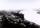
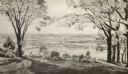
| Date: | 1907 |
|---|---|
| Description: | Elevated view from first peak of Trempealeau, Wisconsin. |

| Date: | 1905 |
|---|---|
| Description: | The view of the Lake Front from across the Mississippi River. Caption reads: "Lake Front at Maiden Rock, Wis." |

| Date: | 1829 |
|---|---|
| Description: | Cincinnati, Ohio, Ebr. Martin, engraver. |

| Date: | 1820 |
|---|---|
| Description: | A manuscript map of Prairie du Chien. |

| Date: | 1870 |
|---|---|
| Description: | Half stereograph of an elevated view from hill showing the confluence of the Mississippi River and the St. Croix River. A man wearing a hat is in the foreg... |

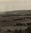
| Date: | 1930 |
|---|---|
| Description: | View of town on opposite shoreline, and piers in the foreground on the right. Taken from the Burlington Railroad bridge. |

| Date: | 1910 |
|---|---|
| Description: | Elevated view from hill of a steamer at Point Douglas going upstream on the Mississippi River. Caption reads: "Mississippi River at Prescott, Wis." |

| Date: | 1882 |
|---|---|
| Description: | This basic reference map of the state shows natural features, railroads, county seats, and political boundaries against the G.L.O. township and range grid.... |

| Date: | 1910 |
|---|---|
| Description: | Wisconsin Geological and Natural History Survey, by Lawrence Martin reproduced from a model of the state prepared by W.O. Hotchkiss and F.T. Thwaites and m... |

| Date: | 1868 |
|---|---|
| Description: | Showing the counties, towns and railroads. Partly colored. Scale: 1 inch = 20 miles. |

| Date: | 1898 |
|---|---|
| Description: | Shows railway lines in Wisconsin marked in red and counties in colors. The meridians are Greenwich, Wisconsin and Washington, Wisconsin. The map folds into... |

| Date: | |
|---|---|
| Description: | Plan of township no. 3 north, range no. 5 west of the 4th principal meridian. |
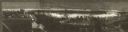
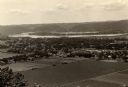
| Date: | 1954 |
|---|---|
| Description: | View from Brisbois Point. Prairie du Chien lies below, and beyond the Mississippi River rise Iowa's hills. |

| Date: | 1836 |
|---|---|
| Description: | Woodcut of Prairie du Chien in 1836. Text at bottom reads: "Prairie du Chien in 1836. From an old cut." |
| Date: | 1910 |
|---|---|
| Description: | Elevated view from Brisbois Bluff of town, Mississippi River, and hills beyond. |
If you didn't find the material you searched for, our Library Reference Staff can help.
Call our reference desk at 608-264-6535 or email us at: