 Filter: Categories of Wisconsin Historical Images
Filter: Subject of Mississippi River
Filter: Subject of hotels
Filter: Categories of Wisconsin Historical Images
Filter: Subject of Mississippi River
Filter: Subject of hotels

| Date: | 1880 |
|---|---|
| Description: | Bird's-eye map over the Mississippi River of Fountain City. Paddle steamers and steamboats are on the river, and bluffs are in the background. |
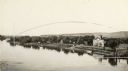
| Date: | 1931 |
|---|---|
| Description: | Mississippi River from the Brisbois Mansion. Left to right: Dousman House Hotel, railroad station, electrical plant smokestack, Diamond Jo warehouse, and a... |
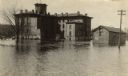
| Date: | 1916 |
|---|---|
| Description: | Dousman House hotel, surrounded by Mississippi River flood water in spring. View looking northwest. |
| Date: | 1900 |
|---|---|
| Description: | The Dousman House as seen from the Mississippi River. Caption reads: "Dousman House, East Bank of Mississippi River, Prairie Du Chien, Wis." |
| Date: | 1900 |
|---|---|
| Description: | The Dousman Hotel seen from an elevated view of the Mississippi River. |
| Date: | |
|---|---|
| Description: | A blurred image of a man as he is walking across the unpaved street which goes down to the Mississippi River. The Bay State House and more storefronts are ... |

| Date: | 1950 |
|---|---|
| Description: | This road map shows federal, state and county roads in Wisconsin, northern Illinois, northeastern Iowa, eastern Minnesota, and the western portion of Michi... |

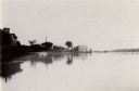
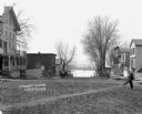
| Date: | |
|---|---|
| Description: | View over town, including hotel and church, towards the Mississippi River. The far shoreline and bluffs are in the distance. |

| Date: | 1886 |
|---|---|
| Description: | This map has relief shown by hachures and includes a list of plats in order of date of record, laws which vacate plats, plats not shown as upon the county ... |

| Date: | 1950 |
|---|---|
| Description: | Intended for tourists, this brochure features two maps with tourists sites along the Mississippi River. One map shows roads and populated places along the ... |

| Date: | 1929 |
|---|---|
| Description: | This map shows the entire state of Wisconsin and Minnesota and portions of Illinois and Iowa. Counties, cities, highways, lakes, and rivers are labeled. Ro... |

| Date: | 1928 |
|---|---|
| Description: | This map shows the entire state of Wisconsin as well as portions of Michigan, Minnesota, Iowa and Illinois. Lake Michigan, Lake Superior, Lake Winnebago a... |

| Date: | 1935 |
|---|---|
| Description: | This road map shows automobile routes across the state of Wisconsin. Advertisements for various hotels are featured along the bottom edge of the map, while... |

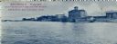
| Date: | |
|---|---|
| Description: | View across Mississippi River towards the La Crosse waterfront. Postcard is folded in four parts, and text on front reads: "Mail Card. Write on back of thi... |

| Date: | |
|---|---|
| Description: | Aerial view of the Holiday Inn, between La Crosse on Barron Island in the beautiful Mississippi. A curved road is leading to a bridge across the Mississipp... |
If you didn't find the material you searched for, our Library Reference Staff can help.
Call our reference desk at 608-264-6535 or email us at: