 Filter: Categories of Wisconsin Historical Images
Filter: Subject of Mississippi River
Filter: Subject of cities and towns
Filter: Categories of Wisconsin Historical Images
Filter: Subject of Mississippi River
Filter: Subject of cities and towns
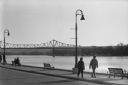
| Date: | 1998 |
|---|---|
| Description: | A couple walking along the riverfront in winter, with a bridge across the Mississippi in the background. |

| Date: | 1828 |
|---|---|
| Description: | Plat of the Private Claims at Prairie Du Chien. |
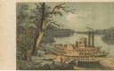
| Date: | |
|---|---|
| Description: | Drawing of Grand Turk steamboat on the river's edge. Print is part of a series collected in Lewis' "Das Illustririte Mississippithal". |
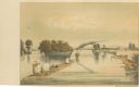
| Date: | |
|---|---|
| Description: | Drawing of Savannah, Illinois, depicting a small town along the shore of the Mississippi River. There is a steamboat in the foreground. Print is part of a ... |
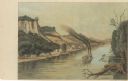
| Date: | |
|---|---|
| Description: | Lithographed drawing of the mouth of the St. Croix River depicting a sailing barge and steamboat in the distance. Print is part of a series collected in Le... |

| Date: | 1937 |
|---|---|
| Description: | Official state highway map, with insets of cities. |

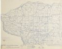
| Date: | 1932 |
|---|---|
| Description: | This map includes a distance table, text, and insets maps of, Superior, Ashland, Marinette, Green Bay, Appleton, Manitowoc, Oshkosh, Fond Du Lac, Janesvill... |

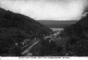
| Date: | |
|---|---|
| Description: | View from river of Fountain City's shoreline with bluffs in the background. Caption reads: "Fountain City, Wis." |
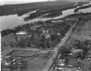
| Date: | 03 28 1949 |
|---|---|
| Description: | Aerial view of Prairie du Chien showing the Mississippi River in the background. |
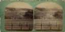
| Date: | |
|---|---|
| Description: | Elevated view of St. Anthony's Fall. Caption on back of stereograph reads, "St. Anthony's Falls, Minneapolis, Minn." There is a bridge in the foreground, a... |
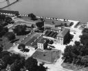
| Date: | |
|---|---|
| Description: | Aerial view of the Prairie du Chien plant of Oscar Mayer & Co. |
| Date: | 1896 |
|---|---|
| Description: | Section 4 of 12, this bicycle road map features Wisconsin bicycle routes in the counties of Iowa, Grant, and La Fayette. |

| Date: | 1896 |
|---|---|
| Description: | Section 5 of 12, this bicycle road map features Wisconsin bicycle routes in the counties of La Crosse, Monroe, Vernon, Crawford, Richland, Sauk, Juneau, an... |
| Date: | |
|---|---|
| Description: | An elevated view of the town of Clayton, Iowa, which is nestled in a valley. The Mississippi River can be seen nearby. Caption reads: "Clayton, Iowa, on th... |
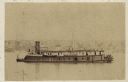
| Date: | 1864 |
|---|---|
| Description: | Union gunboat "Prairie Bird," a small rear-wheel steamship. |

| Date: | 1887 |
|---|---|
| Description: | Men on shoreline are returning logs with horses, which have been stranded on a sandbar, to the main channel of the Mississippi River. Beef Slough Company w... |
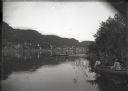
| Date: | 1890 |
|---|---|
| Description: | Oblique view from the Mississippi River. Two young women are in a rowboat near the shoreline, and two young men are fishing in the river. Alma at the foot ... |
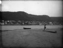
| Date: | 1890 |
|---|---|
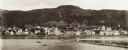
| Description: | View of Alma across river from sandbar. A rowboat is on the sandbar, and on the right a father and child are standing posed each with one foot on a log. |
| Date: | 1885 |
|---|---|
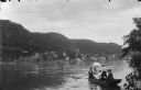
| Description: | Four men and one woman in a rowboat on the Mississippi River. In the background is the town of Alma at the foot of bluffs. The woman is holding an umbrella... |
| Date: | 1897 |
|---|---|
| Description: | View of Alma from the Mississippi River, with wing dam on right. |
If you didn't find the material you searched for, our Library Reference Staff can help.
Call our reference desk at 608-264-6535 or email us at: