 Filter: Categories of Wisconsin Historical Images
Filter: Subject of Mississippi River
Filter: Subject of cities and towns
Filter: Subject of transportation
Filter: Categories of Wisconsin Historical Images
Filter: Subject of Mississippi River
Filter: Subject of cities and towns
Filter: Subject of transportation

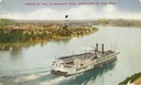
| Date: | 1902 |
|---|---|
| Description: | Hand-colored Mississippi River view with steamboat and rowboat in the river. |

| Date: | 1856 |
|---|---|
| Description: | This map show the surveyed southern part of state and includes "profile of the Milwaukee and Mississippi Rail Road." Counties are shown in pink, green, blu... |

| Date: | 1886 |
|---|---|
| Description: | This map shows U.S. land offices, completed railroads, railroad land grant limits, lakes, rivers, and Indian reservations. Communities, lakes, and rivers a... |

| Date: | 1874 |
|---|---|
| Description: | This map shows lakes, rivers, state, county, and town boundaries, as well as railroads completed, in progress, and contemplated. The map includes a color d... |

| Date: | 1870 |
|---|---|
| Description: | During the War of 1812, the only battle fought in Wisconsin was in Prairie du Chien, in 1814. Made fifty-six years later, this birds eye drawing depicts th... |
| Date: | |
|---|---|
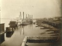
| Description: | The sternwheel packet, Arkansas, next to a barge with other steamboats at the levee in Winona between 1870 and 1880. Railway cars are on a siding in... |
| Date: | |
|---|---|
| Description: | View along shoreline of the sternwheel excursion, J.S., getting ready to leave for Winona. A crowd is watching from the landing. A crane on the fron... |

| Date: | 1873 |
|---|---|
| Description: | The harbor, showing the sidewheel packet, "Belle of La Crosse," and the sidewheel ferry "Alex McGregor." Other boats are also seen including two barges loa... |
| Date: | 1858 |
|---|---|
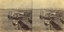
| Description: | Elevated view of the sidewheel packet, Keokuk, at the Winona, Minnesota levee between 1858 and 1866. A barge and railway cars are in the foreground. |
| Date: | 1900 |
|---|---|
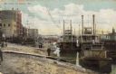
| Description: | Riverboats tied at the levee in La Crosse with the Gypsy in the foreground. Caption reads: "The Levee, La Crosse, Wis." |
| Date: | 1909 |
|---|---|
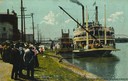
| Description: | Elevated view of the sidewheel excursion, Saint Paul, on the Mississippi River taken in 1909. St. Paul, Minnesota is seen in the background. Later n... |

| Date: | 1867 |
|---|---|
| Description: | Bird's-eye map of La Crosse with nine insets of residences, schools, and the Court House and Jail. |

| Date: | 1873 |
|---|---|
| Description: | Bird's-eye map of La Crosse from the Mississippi River. |

| Date: | 1880 |
|---|---|
| Description: | Bird's-eye map over the Mississippi River of Fountain City. Paddle steamers and steamboats are on the river, and bluffs are in the background. |
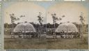
| Date: | 1880 |
|---|---|
| Description: | Stereograph of the Artesian Well near the intersection of Wisconsin and Minnesota (later renamed Wacouta) Streets. The following is printed on the backside... |
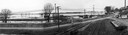
| Date: | 04 22 1965 |
|---|---|
| Description: | A panoramic view of the Mississippi River flooding during the spring, showing the dykes built along the Chicago, Burlington & Quincy Railroad tracks at Sec... |
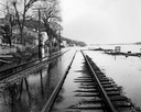
| Date: | 04 21 1965 |
|---|---|
| Description: | View down flooded railroad tracks of the Chicago, Burlington & Quincy Railroad by the Mississippi River. There are houses on the left, and in the backgroun... |

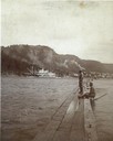
| Date: | |
|---|---|
| Description: | View across the Mississippi River of Eagle Bluff and Fountain City, with a man in the foreground. The steamer "U.S. Gen. Barnard" is at a landing and a row... |
| Date: | |
|---|---|
| Description: | Two men on an 1,150 foot long swing boom above Alma, which is in the distance on the opposite shoreline. |
If you didn't find the material you searched for, our Library Reference Staff can help.
Call our reference desk at 608-264-6535 or email us at:
