 Filter: Categories of Wisconsin Historical Images
Filter: Subject of Mississippi River
Filter: Subject of church buildings
Filter: Categories of Wisconsin Historical Images
Filter: Subject of Mississippi River
Filter: Subject of church buildings

| Date: | 1880 |
|---|---|
| Description: | Bird's-eye map over the Mississippi River of Fountain City. Paddle steamers and steamboats are on the river, and bluffs are in the background. |
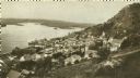
| Date: | 1905 |
|---|---|
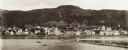
| Description: | View of Alma from across the Mississippi River. Caption reads: "Alma, Wis." |
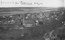
| Date: | 1900 |
|---|---|
| Description: | View from bluff looking northwest at the town of Cassville. A church in the center is the dominant structure in the foreground. Caption reads: "Souvenir - ... |
| Date: | |
|---|---|
| Description: | Cassville from the bluffs. Bluffs are in the right side of the image, and the view overlooks the town. The church is the dominant structure, and the river ... |
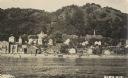
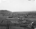
| Date: | 1920 |
|---|---|
| Description: | Elevated view of Fountain City with the Mississippi River in the background. |
| Date: | 1910 |
|---|---|
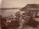
| Description: | Elevated view of Genoa along the Mississippi River. Scene of the last battle between the United States forces and the Native Americans under Chief Black Ha... |
| Date: | 1890 |
|---|---|
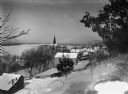
| Description: | A view from a hill overlooking the town of Alma, on the banks of the Mississippi River, which is frozen. Several churches and residential houses are visibl... |
| Date: | 1897 |
|---|---|
| Description: | View of Alma from the Mississippi River, with wing dam on right. |

| Date: | 1908 |
|---|---|
| Description: | Photographic postcard view over the Mississippi River showing of the town of Alma. Bluffs are behind the town. In the foreground, two men wearing hats are ... |
| Date: | 1922 |
|---|---|
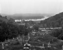
| Description: | View from the hilltop at the Genoa cemetery looking down towards the village, the Mississippi River and the Minnesota border. |

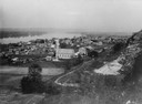
| Date: | 1900 |
|---|---|
| Description: | Elevated view over city. A church is in the middle foreground, and the Mississippi River and far shoreline is in the background. On the right side is a dir... |

| Date: | |
|---|---|
| Description: | View down Denniston Avenue. On the left side behind a long row of fences along the sidewalk are dwellings and a church. On the right side dwellings are alo... |

| Date: | 1922 |
|---|---|
| Description: | This map of Pierce County, Wisconsin, from the first half of the 20th century, shows the township and range grid, towns, sections, villages, roads, railroa... |

| Date: | 1911 |
|---|---|
| Description: | Blue line print. Shows post offices, houses, schools, churches, roads, routes, rivers, and railroads. Includes explanation of symbols. "H.G.M. October 12,... |

| Date: | |
|---|---|
| Description: | View over town, including hotel and church, towards the Mississippi River. The far shoreline and bluffs are in the distance. |

| Date: | |
|---|---|
| Description: | Elevated view of Cassville, including the town hall and St. Peter's Church. |
| Date: | |
|---|---|
| Description: | View down hill towards Stoddard, with the Mississippi River and hills in the background. The German Lutheran Church is in the foreground, and there are rai... |

| Date: | |
|---|---|
| Description: | Colorized, elevated view of Cassville with the Mississippi River in the background. A church and dwellings are in the foreground. |

| Date: | 1859 |
|---|---|
| Description: | This map show plats including plat names, plat numbers, and some lot owner's names. Relief is shown by hachures. The map includes line drawings of Juneau B... |
If you didn't find the material you searched for, our Library Reference Staff can help.
Call our reference desk at 608-264-6535 or email us at:
