Filter: Categories of Wisconsin Historical Images
Filter: Subject of Mississippi River
Filter: County of La Crosse
Filter: Categories of Wisconsin Historical Images
Filter: Subject of Mississippi River
Filter: County of La Crosse

| Date: | 1998 |
|---|---|
| Description: | A couple walking along the riverfront in winter, with a bridge across the Mississippi in the background. |
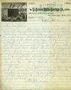
| Date: | 1887 |
|---|---|
| Description: | Letterhead of the La Crosse Wallis Carriage Co., manufacturers of fine family carriages, showing a view of the factory with the Mississippi River in the ba... |

| Date: | |
|---|---|
| Description: | A view of the control gates on the federal floor control dam on the Mississippi River, in the La Crosse vicinity. |

| Date: | 2010 |
|---|---|
| Description: | Bridge over the Mississippi River on foggy morning. |

| Date: | 2004 |
|---|---|
| Description: | The "Delta Queen" steamboat at dock. People are walking across the gangplank toward the shoreline. |

| Date: | |
|---|---|
| Description: | Memohead of the G. Heileman Brewing Company of La Crosse, Wisconsin, manufacturers of keg and bottled beer, with an elevated view of the brewery complex, i... |

| Date: | |
|---|---|
| Description: | Letterhead of the John Gund Brewing Company of La Crosse, Wisconsin, with an elevated view of the brewery complex on the left. On the right is the company ... |
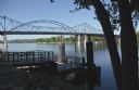
| Date: | 2010 |
|---|---|
| Description: | View of two bridges, a pier, and trees along the Mississippi River. |

| Date: | 1873 |
|---|---|
| Description: | A map that covers parts of Winona and Houston Counties, Minnesota and La Crosse County, Wisconsin, showing the proposed railroad routes, constructed rail l... |

| Date: | |
|---|---|
| Description: | A map of La Crosse, Wisconsin and La Crescent, Minnesota, showing sectional divisions along the shore and islands of the Mississippi River. The areas also ... |
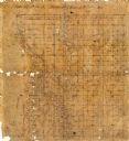
| Date: | |
|---|---|
| Description: | This 19th century manuscript map shows state lands and acreages along the Mississippi River and the sections in parts of what is currently the Town of Shel... |

| Date: | 1880 |
|---|---|
| Description: | This map of La Crosse shows the Chicago, Milwaukee and St. Paul Railroad, the Southern Minnesota Railroad and the Chicago, Dubuque and Minnesota Railroad, ... |

| Date: | 1891 |
|---|---|
| Description: | This map of La Crosse shows eighteen city wards in red, railroads, cemeteries, fair grounds, labeled streets, islands, and the Mississippi River. The left ... |

| Date: | 1893 |
|---|---|
| Description: | This map of La Crosse shows city ward boundaries in red, streets, railroads, cemeteries, Grand station crossing, the road to French Island, depots, Lake Pa... |

| Date: | 1893 |
|---|---|
| Description: | This map of La Crosse shows wards 1-20, streets, railroads, the Inter State Fair Grounds, islands, and the Mississippi River. Relief is shown by hachures. ... |

| Date: | 1940 |
|---|---|
| Description: | This map of La Crosse shows different types of land zoning: residence, multiple dwelling, local business, commercial, light industrial, heavy industrial, w... |

| Date: | 1950 |
|---|---|
| Description: | This map is intended for tourists visiting La Crosse. The front of the map provides extensive text on attractions and activities in La Crosse while the bac... |

| Date: | 1954 |
|---|---|
| Description: | This map of La Crosse shows residential, multiple dwelling, local business, commercial, light industrial, heavy industrial and special multiple dwelling la... |

| Date: | 1956 |
|---|---|
| Description: | This map is intended for tourists of La Crosse. The front of the map is text about attractions, activities, and accommodations in La Crosse. The back is th... |
If you didn't find the material you searched for, our Library Reference Staff can help.
Call our reference desk at 608-264-6535 or email us at: