 Filter: Categories of Wisconsin Historical Images
Filter: Subject of Mississippi River
Filter: County of Crawford
Filter: Categories of Wisconsin Historical Images
Filter: Subject of Mississippi River
Filter: County of Crawford

| Date: | |
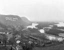
|---|---|
| Description: | View toward a river and surrounding landscape, taken from a high vantage point. In the foreground are a series of wooden structures. Trees line the river a... |

| Date: | |
|---|---|
| Description: | View across water toward a railroad bridge, constructed of heavy steel that sits on massive stone supports. Wooded hills are in the background. |
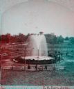
| Date: | 1880 |
|---|---|
| Description: | Stereograph of the Artesian Well near the intersection of Wisconsin and Minnesota (later renamed Wacouta) Streets. The following is printed on the back of ... |
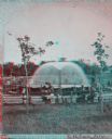
| Date: | 1880 |
|---|---|
| Description: | Stereograph of the Artesian Well near the intersection of Wisconsin and Minnesota (later renamed Wacouta) Streets. The following is printed on the backside... |
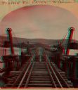
| Date: | 1870 |
|---|---|
| Description: | Stereograph of John Lawler's pile-pontoon railway bridge over the Mississippi River. |

| Date: | |
|---|---|
| Description: | Elevated panoramic view of the west lawn at Villa Louis. Several trees and shrubs, a flag pole, and a swimming hole can be seen in the yard. A pontoon rail... |
| Date: | 1914 |
|---|---|
| Description: | View down path along rough road towards a building labeled "No. 4". The De Soto Depot, railroad tracks, a boxcar, and the Mississippi River are below on th... |
| Date: | |
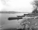
|---|---|
| Description: | View of shoreline of boats tied along the banks the Mississippi River. A fish net drying reel is near the boats and a wooden walkway. The far shoreline is ... |
| Date: | |
|---|---|
| Description: | A blurred image of a man as he is walking across the unpaved street which goes down to the Mississippi River. The Bay State House and more storefronts are ... |
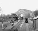
| Date: | 1912 |
|---|---|
| Description: | Elevated view of the De Soto depot. A locomotive, blowing steam, is approaching the platform, where a small group of people waits to board. A boxcar on the... |
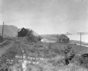
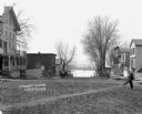
| Date: | |
|---|---|
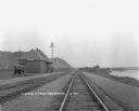
| Description: | View looking down bluff of a residential neighborhood. On the right is the Mississippi River. Railroad tracks run along the shoreline towards more bluffs. |
| Date: | 1925 |
|---|---|
| Description: | View down double set of railroad tracks with the De Soto depot on the left and the Mississippi River on the right. A car is parked at the depot, and bluffs... |

| Date: | |
|---|---|
| Description: | This 19th century manuscript map shows the township and range systems, sections, and acreages along the Mississippi River in the towns of Freeman and Senec... |

| Date: | |
|---|---|
| Description: | This 19th century manuscript map shows land claims near the confluence of the Wisconsin River with the Mississippi River in the Town of Bridgeport, Crawfor... |

| Date: | 1911 |
|---|---|
| Description: | Blue line print. Shows post offices, houses, schools, churches, roads, routes, rivers, and railroads. Includes explanation of symbols. "H.G.M. October 12,... |

| Date: | |
|---|---|
| Description: | "Section of New Prairie du Chien Marquette $1,000,000 Suspension Bridge. Total length 3729 feet. Only suspension bridge on the Mississippi River. Open for ... |

| Date: | |
|---|---|
| Description: | View from shoreline of the "Capitol" excursion steamer pulled up to the bank of the Mississippi. The steamer has three or four decks, and elaborately detai... |
| Date: | 1915 |
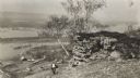
|---|---|
| Description: | Elevated view of the Mississippi River from a bluff. There is a farm and other houses along the shoreline, and in the foreground a boy stands on the bluff ... |

| Date: | 1882 |
|---|---|
| Description: | This map is ink on cardboard and shows the location of military forts over the course of years. Also shown are points of interest, streets, the Mississippi... |

| Date: | 01 15 1929 |
|---|---|
| Description: | Intended for tourists, this brochure, titled: "Winneshiek World’s Famous Wild Life Refuge Historic Fort Crawford and Picturesque Prairie du Chien," feature... |
If you didn't find the material you searched for, our Library Reference Staff can help.
Call our reference desk at 608-264-6535 or email us at: